IMAGES TAKEN NEAR TO
Crookes Lane, WESTON-SUPER-MARE, BS22 9XE
Introduction
This page details the photographs taken nearby to Crookes Lane, BS22 9XE by members of the Geograph project.
The Geograph project started in 2005 with the aim of publishing, organising and preserving representative images for every square kilometre of Great Britain, Ireland and the Isle of Man.

There are currently over 7.5m images from over14,400 individuals and you can help contribute to the project by visiting https://www.geograph.org.uk
Image Map (Loading...)


Getting Data...Please wait
Leaflet Map data © OpenStreetMap
Images are licensed for reuse under creativecommons.org/licenses/by-sa/2.0
Notes
- Clicking on the map will re-center to the selected point.
- The higher the marker number, the further away the image location is from the centre of the postcode.
Image Listing (70 Images Found)
Images are licensed for reuse under creativecommons.org/licenses/by-sa/2.0
Image
Details
Distance
1
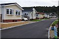
Kewstoke : Ardnave Caravan Site
The driveway up into the caravan and holiday home site.
Image: © Lewis Clarke
Taken: 3 Oct 2012
0.02 miles
2
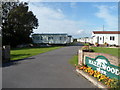
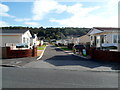
Hazelwood Park. Kewstoke
Park homes site viewed from Crookes Lane. A park home is a detached bungalow-style house, usually in a private estate, as here, located on plots known as pitches. Legally, they are mobile homes and are covered by their own legislation.
Image: © Jaggery
Taken: 27 Sep 2012
0.03 miles
3
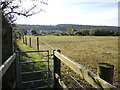
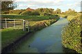
Path to Kewstoke
The path is bounded by rhynes and equine paddocks.
Image: © Neil Owen
Taken: 12 Oct 2021
0.03 miles
4
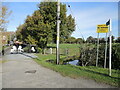
Path by Hazelwood Park
The public footpath leaves the road here and skirts to the north of the private estate. Next destination: Kewstoke.
Image: © Neil Owen
Taken: 12 Oct 2021
0.03 miles
5
Entrance to Ardnave Park, Kewstoke
Park homes view from Crookes Lane. A park home is a detached bungalow-style house, usually in a private estate, as here, located on plots known as pitches. Legally, they are mobile homes and are covered by their own legislation.
Image: © Jaggery
Taken: 27 Sep 2012
0.04 miles
6
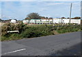
Rhyne, Kewstoke
From a bend in Crook's Lane by Ardnave Park.
Image: © Derek Harper
Taken: 18 Oct 2016
0.05 miles
7
Western end of Lower Norton Lane, Kewstoke
Viewed from the corner of Crookes Lane.
Image: © Jaggery
Taken: 27 Sep 2012
0.09 miles
8
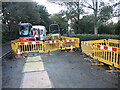
Roadworks in Crookes Lane
October seems to be a popular time for rural road digging.
Image: © Neil Owen
Taken: 4 Nov 2022
0.09 miles
9
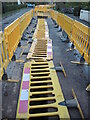
A different use for the barriers
Crookes Lane roadworks shows a new way to use the barriers. Just don't try to walk on the excavations.
Image: © Neil Owen
Taken: 4 Nov 2022
0.09 miles
10
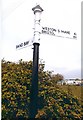
Old Direction Sign - Signpost Kewstoke Parish
Pyramid finial - 2 arms; Somerset SCC pyramid by the UC road, in parish of Kewstoke (North Somerset District), junction of Crookes Lane and Lower Norton Lane, Norton.
Surveyed
Milestone Society National ID: SO_ST3363A
Image: © Milestone Society
Taken: Unknown
0.09 miles