IMAGES TAKEN NEAR TO
Pimms Lane, WESTON-SUPER-MARE, BS22 9TE
Introduction
This page details the photographs taken nearby to Pimms Lane, BS22 9TE by members of the Geograph project.
The Geograph project started in 2005 with the aim of publishing, organising and preserving representative images for every square kilometre of Great Britain, Ireland and the Isle of Man.

There are currently over 7.5m images from over14,400 individuals and you can help contribute to the project by visiting https://www.geograph.org.uk
Image Map
Images are licensed for reuse under creativecommons.org/licenses/by-sa/2.0
Notes
- Clicking on the map will re-center to the selected point.
- The higher the marker number, the further away the image location is from the centre of the postcode.
Image Listing (9 Images Found)
Images are licensed for reuse under creativecommons.org/licenses/by-sa/2.0
Image
Details
Distance
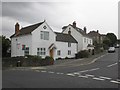
2
Weston Supe Mare Whorlberry
Cottage Whorlberry Hill Road
Image: © norman griffin
Taken: 26 Mar 2011
0.11 miles
5
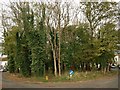
Oval wood, Worlebury Park Road
The residential road splits to enclose this oval patch of broadleaved woodland.
Image: © Derek Harper
Taken: 23 Oct 2008
0.14 miles

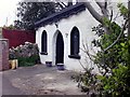
7
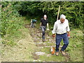
Monk Steps at Kewstoke
Vegetation cleared by National Trust volunteers.
Image: © Paul Harvey
Taken: 16 Jul 2008
0.19 miles
8
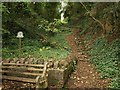
Monk's Steps, Kewstoke
A view from Monkhill at the foot of Image "Monk's steps (also known to some as St Kew's Steps) are an ancient set of stone steps leading from St. Paul's church up through the woods on Monk's Hill. Although the origin of the steps are unknown, the presence of man in the adjacent woodland on Worlebury Hill can be tracked back to the Iron Age." http://en.wikipedia.org/wiki/Kewstoke
Image: © Derek Harper
Taken: 23 Oct 2008
0.23 miles
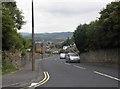
9
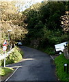
Steep and narrow Monks Hill Kewstoke
Viewed from the Kewstoke Road end.
Signs show a 25% (1 in 4) gradient and 2 metre (6' 6") road width ahead.
Image: © Jaggery
Taken: 27 Sep 2012
0.24 miles