IMAGES TAKEN NEAR TO
Worlebury Hill Road, WESTON-SUPER-MARE, BS22 9TD
Introduction
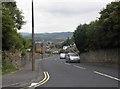
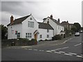
This page details the photographs taken nearby to Worlebury Hill Road, BS22 9TD by members of the Geograph project.
The Geograph project started in 2005 with the aim of publishing, organising and preserving representative images for every square kilometre of Great Britain, Ireland and the Isle of Man.

There are currently over 7.5m images from over14,400 individuals and you can help contribute to the project by visiting https://www.geograph.org.uk
Image Map
Images are licensed for reuse under creativecommons.org/licenses/by-sa/2.0
Notes
- Clicking on the map will re-center to the selected point.
- The higher the marker number, the further away the image location is from the centre of the postcode.
Image Listing (4 Images Found)
Images are licensed for reuse under creativecommons.org/licenses/by-sa/2.0
Image
Details
Distance
3
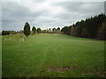
Worlebury Golf Course
Looking out from the 4th Tee
Image: © Adrian and Janet Quantock
Taken: 25 Nov 2005
0.19 miles
4
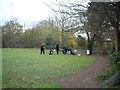
Golfers on the 4th Tee
Worlebury Golf course
Image: © Adrian and Janet Quantock
Taken: 26 Nov 2005
0.19 miles