IMAGES TAKEN NEAR TO
Worlebury Park Road, WESTON-SUPER-MARE, BS22 9SA
Introduction
This page details the photographs taken nearby to Worlebury Park Road, BS22 9SA by members of the Geograph project.
The Geograph project started in 2005 with the aim of publishing, organising and preserving representative images for every square kilometre of Great Britain, Ireland and the Isle of Man.

There are currently over 7.5m images from over14,400 individuals and you can help contribute to the project by visiting https://www.geograph.org.uk
Image Map (Loading...)


Getting Data...Please wait
Leaflet Map data © OpenStreetMap
Images are licensed for reuse under creativecommons.org/licenses/by-sa/2.0
Notes
- Clicking on the map will re-center to the selected point.
- The higher the marker number, the further away the image location is from the centre of the postcode.
Image Listing (11 Images Found)
Images are licensed for reuse under creativecommons.org/licenses/by-sa/2.0
Image
Details
Distance
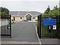
1
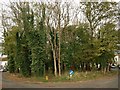
Oval wood, Worlebury Park Road
The residential road splits to enclose this oval patch of broadleaved woodland.
Image: © Derek Harper
Taken: 23 Oct 2008
0.02 miles
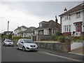
3
Weston Supe Mare Whorlberry
Cottage Whorlberry Hill Road
Image: © norman griffin
Taken: 26 Mar 2011
0.14 miles
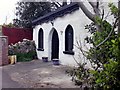
5
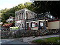
The New Castle for sale, Kewstoke
At the September 2012 date of this view, there was an estate agent's For Sale notice on the wall
of the freehold restaurant, coffee lounge and bar (with accommodation).
Image: © Jaggery
Taken: 27 Sep 2012
0.19 miles
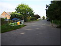
6
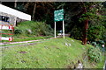
Kewstoke entrance to Weston Woods
Viewed from Kewstoke Road. The notice shows Site of Iron Age Hill Fort.
Image: © Jaggery
Taken: 27 Sep 2012
0.19 miles
7
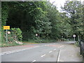
Pay no toll
The section of Kewstoke Road that takes in the edge of the coastal run along the Worle peninsula was once a toll road. That has not been the case for many years now and the toll booth has gone, leaving the road clear to all. Villagers are asking for the tolls to be reinstated but the local council are not convinced the move would make economic sense. Meanwhile the road and its twisty nature along a rocky shoreline has had more than its fair share of serious crashes.
Image: © Neil Owen
Taken: 12 Oct 2021
0.21 miles
8
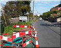
Roadworks near the Kewstoke boundary sign
Kewstoke Road from Weston-super-Mare reaches the village of Kewstoke in North Somerset.
Image: © Jaggery
Taken: 27 Sep 2012
0.21 miles
10
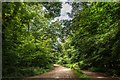
Weston Woods, Weston-Super-Mare
One of the main routes through the woods, taken just beyond the main car park. This section is marked as a restricted byway on the Ordnance Survey maps, but later becomes a bridleway.
Image: © Oliver Mills
Taken: 22 Jul 2020
0.22 miles