IMAGES TAKEN NEAR TO
Naunton Way, WESTON-SUPER-MARE, BS22 9QW
Introduction
This page details the photographs taken nearby to Naunton Way, BS22 9QW by members of the Geograph project.
The Geograph project started in 2005 with the aim of publishing, organising and preserving representative images for every square kilometre of Great Britain, Ireland and the Isle of Man.

There are currently over 7.5m images from over14,400 individuals and you can help contribute to the project by visiting https://www.geograph.org.uk
Image Map (Loading...)


Getting Data...Please wait
Leaflet Map data © OpenStreetMap
Images are licensed for reuse under creativecommons.org/licenses/by-sa/2.0
Notes
- Clicking on the map will re-center to the selected point.
- The higher the marker number, the further away the image location is from the centre of the postcode.
Image Listing (8 Images Found)
Images are licensed for reuse under creativecommons.org/licenses/by-sa/2.0
Image
Details
Distance
1
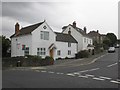
Weston Supe Mare Whorlberry
Cottage Whorlberry Hill Road
Image: © norman griffin
Taken: 26 Mar 2011
0.09 miles
3
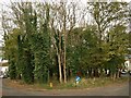
Oval wood, Worlebury Park Road
The residential road splits to enclose this oval patch of broadleaved woodland.
Image: © Derek Harper
Taken: 23 Oct 2008
0.21 miles
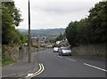
5
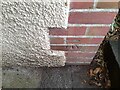
Ordnance Survey Cut Mark
This OS cut mark can be found on the PC SE side of Upper Bristol Road. It marks a point 41.331m above mean sea level.
Image: © Adrian Dust
Taken: 13 Jul 2023
0.23 miles
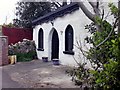
6
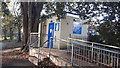
Public Conveniences, Ashcombe Park, Weston Super Mare
Image: © V1ncenze
Taken: 18 Nov 2019
0.23 miles
7
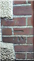
Ordnance Survey Bench Mark
Bench Mark located on the public conveniences in Ashcombe Park, Weston Super Mare. These marks were used by Ordnance Survey for mapping purposes.
Image: © V1ncenze
Taken: 18 Nov 2019
0.24 miles