IMAGES TAKEN NEAR TO
Keyes Path, WESTON-SUPER-MARE, BS22 9QB
Introduction
This page details the photographs taken nearby to Keyes Path, BS22 9QB by members of the Geograph project.
The Geograph project started in 2005 with the aim of publishing, organising and preserving representative images for every square kilometre of Great Britain, Ireland and the Isle of Man.

There are currently over 7.5m images from over14,400 individuals and you can help contribute to the project by visiting https://www.geograph.org.uk
Image Map (Loading...)


Getting Data...Please wait
Leaflet Map data © OpenStreetMap
Images are licensed for reuse under creativecommons.org/licenses/by-sa/2.0
Notes
- Clicking on the map will re-center to the selected point.
- The higher the marker number, the further away the image location is from the centre of the postcode.
Image Listing (94 Images Found)
Images are licensed for reuse under creativecommons.org/licenses/by-sa/2.0
Image
Details
Distance
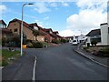
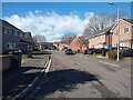
1
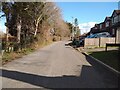
Lyefield Road looking East
Lyefield Road looking East. Ebdon Road Cemetery is on the left and Keyes Path is on the right.
Image: © s
Taken: 14 Mar 2023
0.02 miles
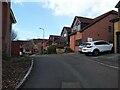
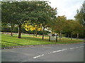
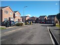
5
Cornwallis Avenue looking Northeast
Fraser Close is on the left. It was built in 1985.
Image: © s
Taken: 27 Mar 2023
0.08 miles
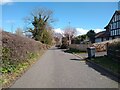
7
Lyefield Road looking East
Lyefield Road looking East towards the junction with Ebdon Road.
Image: © s
Taken: 14 Mar 2023
0.09 miles
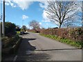
8
Crematorium
The grounds of Weston-Super-Mare and area crematorium
Image: © Adrian and Janet Quantock
Taken: 9 Oct 2005
0.10 miles
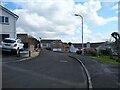
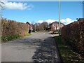
10
Collingwood Close looking Southeast
Collingwood Close looking Southeast towards the junction with Cornwallis Avenue
Image: © s
Taken: 14 Mar 2023
0.10 miles