IMAGES TAKEN NEAR TO
Harwood Green, WESTON-SUPER-MARE, BS22 9LL
Introduction
This page details the photographs taken nearby to Harwood Green, BS22 9LL by members of the Geograph project.
The Geograph project started in 2005 with the aim of publishing, organising and preserving representative images for every square kilometre of Great Britain, Ireland and the Isle of Man.

There are currently over 7.5m images from over14,400 individuals and you can help contribute to the project by visiting https://www.geograph.org.uk
Image Map
Images are licensed for reuse under creativecommons.org/licenses/by-sa/2.0
Notes
- Clicking on the map will re-center to the selected point.
- The higher the marker number, the further away the image location is from the centre of the postcode.
Image Listing (79 Images Found)
Images are licensed for reuse under creativecommons.org/licenses/by-sa/2.0
Image
Details
Distance
1
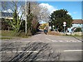
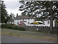
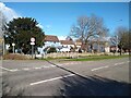
Newton's Road and Queen's Way junction
Junction of Newton's Road and Queen's Way, with the Old Manor Inn (former Manor Farm) on the right. This is the northern section of Newton's Road. It is deatched from the southern section of Newton's Road due to Queen's Way which split Newton's Road in 1979.
Image: © s
Taken: 14 Mar 2023
0.10 miles
2
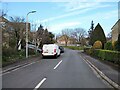
Queen's Way looking East
Queen's Way looking East. The section of the Queen's Way from Ebdon Road to Lower Norton Lane was opened in 1979, the rest was opened two years before, in 1977.
Image: © s
Taken: 14 Mar 2023
0.11 miles
5
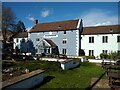
Old Manor Inn
The Old Manor Inn, Worle. Old farmhouse of Manor Farm. Converted into a public house in 1980.
Image: © s
Taken: 14 Mar 2023
0.12 miles
7
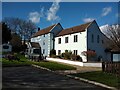
Old Manor Inn
The Old Manor Inn, Worle. Old farmhouse of Manor Farm. Converted into a public house in 1980.
Image: © s
Taken: 14 Mar 2023
0.12 miles
8
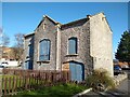
Old barn at former Manor Farm
Old barn and Cart House, located in the car park for the Old Manor Inn. Previously Manor Farm, it was converted into a public house in 1980. The barn doesn't appear on maps until the 1888 OS Map.
Image: © s
Taken: 14 Mar 2023
0.13 miles
9
Old Manor Inn
The Old Manor Inn, Worle. Old farmhouse of Manor Farm. Converted into a public house in 1980.
Image: © s
Taken: 14 Mar 2023
0.13 miles
10
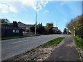
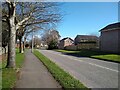
Queen's Way looking West
This section of the Queen's Way (from Ebdon Road to Lower Norton Lane) was built in 1979, with the rest in 1977. The cul-de-sac on the left is Lower Norton Lane which previously connected through what is now the Queen's Way to a junction with Lyefield Road which continued on to Kewstoke and Sand Bay.
Image: © s
Taken: 27 Mar 2023
0.13 miles