IMAGES TAKEN NEAR TO
Anson Road, WESTON-SUPER-MARE, BS22 9LA
Introduction
This page details the photographs taken nearby to Anson Road, BS22 9LA by members of the Geograph project.
The Geograph project started in 2005 with the aim of publishing, organising and preserving representative images for every square kilometre of Great Britain, Ireland and the Isle of Man.

There are currently over 7.5m images from over14,400 individuals and you can help contribute to the project by visiting https://www.geograph.org.uk
Image Map (Loading...)


Getting Data...Please wait
Leaflet Map data © OpenStreetMap
Images are licensed for reuse under creativecommons.org/licenses/by-sa/2.0
Notes
- Clicking on the map will re-center to the selected point.
- The higher the marker number, the further away the image location is from the centre of the postcode.
Image Listing (64 Images Found)
Images are licensed for reuse under creativecommons.org/licenses/by-sa/2.0
Image
Details
Distance
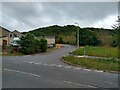
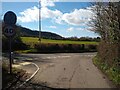
2
Anson Road, somewhere vaguely near Worle
Currently forming the western extent of the housing here, but not according to the 1:50000 map I'm carrying, which dates from the 1950s, my current 1:25000 map being at my destination for tonight. I wonder where I'll get to if I go down here?
Image: © Derek Harper
Taken: 18 Oct 2016
0.03 miles
3
Queen's Way looking Northwest
Queen's Way looking Northwest towards Kewstoke. Lyefield Road leads off the right to Ebdon Road and Woodspring Priory.
Image: © s
Taken: 14 Mar 2023
0.03 miles
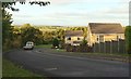
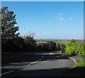
5
Anson Road looking north
Here at the top of Anson Road in the shadow of Worlbury hill we look north over the flat fields that are so typical of the Bristol channel in this area
Image: © Ant Basterfield
Taken: 28 Sep 2011
0.04 miles
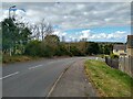
6
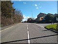
Queen's Way looking Southeast
Queen's Way looking Southeast. The road leading uphill to the right is Anson Road. The section of Queen's Way from Ebdon Road to Lower Norton Lane opened in 1979, the rest in 1977.
Image: © s
Taken: 14 Mar 2023
0.04 miles
8
Queen's Way looking Southeast
This section of the Queen's Way from Ebdon Road to Lower Norton Lane was built in 1979, with the homes on the right at The Dell being built in 2004 on land formerly part of The Newtons.
Image: © s
Taken: 27 Mar 2023
0.05 miles
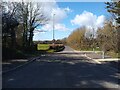
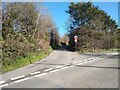
9

Queen's Way and Lyefield Road junction
Junction of Queen's Way and Lyefield Road. The 1980s houses in the background are off Anson Road. This section of Queen's Way opened in 1979.
Image: © s
Taken: 14 Mar 2023
0.05 miles
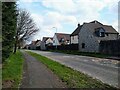
10
Lyefield Road and Queen's Way junction
Junction of Lyefield Road and Queen's Way (section built 1979)
Image: © s
Taken: 14 Mar 2023
0.05 miles