IMAGES TAKEN NEAR TO
Lower Kewstoke Road, WESTON-SUPER-MARE, BS22 9JR
Introduction
This page details the photographs taken nearby to Lower Kewstoke Road, BS22 9JR by members of the Geograph project.
The Geograph project started in 2005 with the aim of publishing, organising and preserving representative images for every square kilometre of Great Britain, Ireland and the Isle of Man.

There are currently over 7.5m images from over14,400 individuals and you can help contribute to the project by visiting https://www.geograph.org.uk
Image Map (Loading...)


Getting Data...Please wait
Leaflet Map data © OpenStreetMap
Images are licensed for reuse under creativecommons.org/licenses/by-sa/2.0
Notes
- Clicking on the map will re-center to the selected point.
- The higher the marker number, the further away the image location is from the centre of the postcode.
Image Listing (34 Images Found)
Images are licensed for reuse under creativecommons.org/licenses/by-sa/2.0
Image
Details
Distance
3
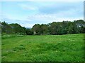
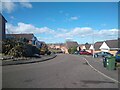
Lynch Farm
Lynch Farm became a park and open space in 1982.
Image: © s
Taken: 12 May 2023
0.12 miles
4
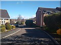
Bramblewood Road looking Southeast
Bramblewood Road was built in 1982.
Image: © s
Taken: 16 May 2023
0.14 miles
7
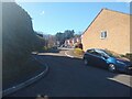
Rookery Close looking Southwest
Rookery Close looking Southwest towards the junction of Bramblewood Road. Part of Lynch Farm until the early 1980s when this area was developed.
Image: © s
Taken: 14 Mar 2023
0.15 miles
8
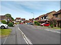
Savernake Road looking Northwest
Savernake Road was built in 1983.
Image: © s
Taken: 18 May 2023
0.15 miles
9
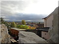
over the Pub Garden wall
This is the garden of the Old Kings Head in Worle, the lumps of stone that are in the foreground is the top of the pub garden wall. in the distance is the start of the Mendip hills which stretch eastwards for some miles.
Image: © Ant Basterfield
Taken: 11 Nov 2022
0.16 miles
10
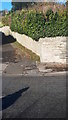
Old Concrete Gatepost
Unused concrete gatepost next to wall. Located on Church Road, Worle.
Image: © V1ncenze
Taken: 18 Nov 2019
0.17 miles