IMAGES TAKEN NEAR TO
Hawthorn Coombe, WESTON-SUPER-MARE, BS22 9EE
Introduction
This page details the photographs taken nearby to Hawthorn Coombe, BS22 9EE by members of the Geograph project.
The Geograph project started in 2005 with the aim of publishing, organising and preserving representative images for every square kilometre of Great Britain, Ireland and the Isle of Man.

There are currently over 7.5m images from over14,400 individuals and you can help contribute to the project by visiting https://www.geograph.org.uk
Image Map
Images are licensed for reuse under creativecommons.org/licenses/by-sa/2.0
Notes
- Clicking on the map will re-center to the selected point.
- The higher the marker number, the further away the image location is from the centre of the postcode.
Image Listing (13 Images Found)
Images are licensed for reuse under creativecommons.org/licenses/by-sa/2.0
Image
Details
Distance
1
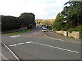
Looking up Hawthorn Hill
A quiet moment on this usually busy suburban road (though local schools haven't turned out yet) while the trees in Worlbury woods have taken on their autumn colours.
Image: © Ant Basterfield
Taken: 11 Nov 2022
0.09 miles
2
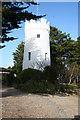
Weston-super-Mare: The Observatory
At the east end of Worlebury Hill, and now part of a private residence. This structure was originally a windmill, at work in 1867, but converted to an observatory in the 1870s
Image: © Martin Bodman
Taken: 9 Mar 2006
0.11 miles
3

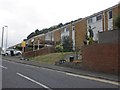
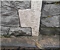
Ordnance Survey Cut Mark
This OS cut mark can be found on No74 Church Road. It marks a point 20.729m above mean sea level.
Image: © Adrian Dust
Taken: 13 Jul 2023
0.16 miles
8

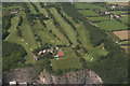
Weston-super-Mare: Worlebury golf course
Looking north
Image: © Martin Bodman
Taken: 9 Mar 2006
0.21 miles
10
Ordnance Survey Cut Mark
This OS cut mark can be found on No24 Coronation Road. It marks a point 13.515m above mean sea level.
Image: © Adrian Dust
Taken: 13 Jul 2023
0.22 miles