IMAGES TAKEN NEAR TO
Spring Hill, WESTON-SUPER-MARE, BS22 9BD
Introduction
This page details the photographs taken nearby to Spring Hill, BS22 9BD by members of the Geograph project.
The Geograph project started in 2005 with the aim of publishing, organising and preserving representative images for every square kilometre of Great Britain, Ireland and the Isle of Man.

There are currently over 7.5m images from over14,400 individuals and you can help contribute to the project by visiting https://www.geograph.org.uk
Image Map (Loading...)


Getting Data...Please wait
Leaflet Map data © OpenStreetMap
Images are licensed for reuse under creativecommons.org/licenses/by-sa/2.0
Notes
- Clicking on the map will re-center to the selected point.
- The higher the marker number, the further away the image location is from the centre of the postcode.
Image Listing (13 Images Found)
Images are licensed for reuse under creativecommons.org/licenses/by-sa/2.0
Image
Details
Distance
1
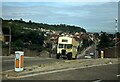
Open-top bus, Church Road, Worle ? 1978
On one of the open-top bus tours run by Bristol Omnibus in the Weston area, this one to the Kewstoke Woods and Sand Bay area with views across the Bristol Channel to South Wales.
This is a bus with a long and colourful history. It started life with Bristol Tramways & Carriage Co in 1941 before moving to the Brighton, Hove & District company where it was converted to open-top for sea front service. In 1965 it was bought by Thomas Bros of Port Talbot, then passed back to Bristol Omnibus in 1969, operating tours in Weston-super-Mare for many years. It went into preservation in 1979, then again reverted to Bristol Omnibus in 1985, operating with it and its successors https://www.geograph.org.uk/photo/6746920 until 2003, since when it has been in the hands of the Bristol Vintage Bus Group. It retains its original Gardner 5LW and had to work hard in low gear on even this short climb up Church Road to Spring Hill.
This is one of a series of views featuring buses in the 60s, 70s, and 80s. http://www.geograph.org.uk/search.php?i=137652761
Image: © Alan Murray-Rust
Taken: 4 Aug 1978
0.15 miles
2
Sparky the Donkey - Weston-super-Mare
Image: © Hazel Stanmore-Richards
Taken: 9 Sep 2010
0.17 miles
3

Service station on the B3440, Weston-super-Mare
Image: © JThomas
Taken: 12 Jul 2019
0.19 miles
4
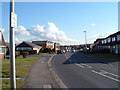
Suburban housing
Houses built in the 1960's on this large estate.
Image: © Ant Basterfield
Taken: 20 Feb 2010
0.21 miles
5
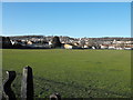
Baytree Rec
The recreation ground, looking towards Worlebury Hill.
Image: © Ant Basterfield
Taken: 1 Jan 2010
0.23 miles
6
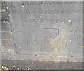
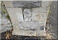
Ordnance Survey Cut Mark
This slightly damaged OS cut mark can be found on the church wall SE side of Milton Road. It marks a point 6.450m above mean sea level.
Image: © Adrian Dust
Taken: 13 Jul 2023
0.23 miles
7
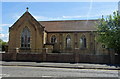
Our Lady of Lourdes Catholic Church, Weston-super-Mare
On Milton Road.
Image: © JThomas
Taken: 12 Jul 2019
0.23 miles
8
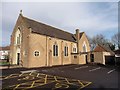
Our Lady of Lourdes, Catholic Church, Milton
Image: © Roger Cornfoot
Taken: 31 Jan 2018
0.24 miles
9
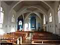
Interior, Our Lady of Lourdes, Catholic Church, Milton
Image: © Roger Cornfoot
Taken: 31 Jan 2018
0.24 miles
10
Ordnance Survey Cut Mark
This OS cut mark can be found on Ivy Lodge on High Street. It marks a point 6.666m above mean sea level.
Image: © Adrian Dust
Taken: 13 Jul 2023
0.24 miles