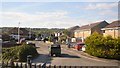
IMAGES TAKEN NEAR TO
Woodpecker Drive, WESTON-SUPER-MARE, BS22 8SR
Introduction
This page details the photographs taken nearby to Woodpecker Drive, BS22 8SR by members of the Geograph project.
The Geograph project started in 2005 with the aim of publishing, organising and preserving representative images for every square kilometre of Great Britain, Ireland and the Isle of Man.

There are currently over 7.5m images from over14,400 individuals and you can help contribute to the project by visiting https://www.geograph.org.uk
Image Map (Loading...)


Getting Data...Please wait
Leaflet Map data © OpenStreetMap
Images are licensed for reuse under creativecommons.org/licenses/by-sa/2.0
Notes
- Clicking on the map will re-center to the selected point.
- The higher the marker number, the further away the image location is from the centre of the postcode.
Image Listing (4 Images Found)
Images are licensed for reuse under creativecommons.org/licenses/by-sa/2.0
Image
Details
Distance

4
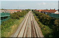
A view NE from a railway footbridge, Weston-super-Mare
Viewed from this http://www.geograph.org.uk/photo/3105464 footbridge. This is the route used by trains that bypass Weston-super-Mare railway station. Worle Junction is ahead, where trains for the station diverge from the main line.
Image: © Jaggery
Taken: 27 Jul 2011
0.25 miles