IMAGES TAKEN NEAR TO
Thorndale Close, WESTON-SUPER-MARE, BS22 8QD
Introduction
This page details the photographs taken nearby to Thorndale Close, BS22 8QD by members of the Geograph project.
The Geograph project started in 2005 with the aim of publishing, organising and preserving representative images for every square kilometre of Great Britain, Ireland and the Isle of Man.

There are currently over 7.5m images from over14,400 individuals and you can help contribute to the project by visiting https://www.geograph.org.uk
Image Map
Images are licensed for reuse under creativecommons.org/licenses/by-sa/2.0
Notes
- Clicking on the map will re-center to the selected point.
- The higher the marker number, the further away the image location is from the centre of the postcode.
Image Listing (41 Images Found)
Images are licensed for reuse under creativecommons.org/licenses/by-sa/2.0
Image
Details
Distance
1
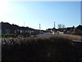
Bungalows in the suburbs
Taken from the start of public footpath that crosses the railway is a view of another quiet Weston Backwater.
Image: © Ant Basterfield
Taken: 20 Feb 2010
0.07 miles
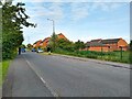
2
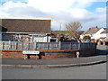
Road junction
Here is the junction of Garsdale Road and Corondale Road with a glimpse of Worlebury Hill the distance.
Image: © Ant Basterfield
Taken: 20 Feb 2010
0.09 miles
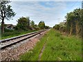
3
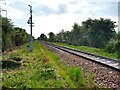
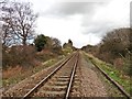
Railway line looking towards Milton Railway Station.
Image: © s
Taken: 17 May 2023
0.15 miles
4
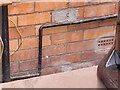
Ordnance Survey Cut Mark
This OS cut mark can be found on No3 Baytree Road. It marks a point 5.910m above mean sea level.
Image: © Adrian Dust
Taken: 13 Jul 2023
0.15 miles
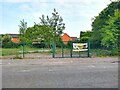
7
Maltlands looking East
The Maltlands was built in 1992 as part of the Locking Castle development.
Image: © s
Taken: 17 May 2023
0.16 miles
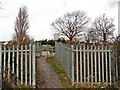
10
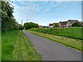
Path off the Maltlands
This path runs from Locking Moor Road to Aspen Park Road along the side of the Railway.
Image: © s
Taken: 17 May 2023
0.16 miles