IMAGES TAKEN NEAR TO
Baytree View, WESTON-SUPER-MARE, BS22 8JR
Introduction
This page details the photographs taken nearby to Baytree View, BS22 8JR by members of the Geograph project.
The Geograph project started in 2005 with the aim of publishing, organising and preserving representative images for every square kilometre of Great Britain, Ireland and the Isle of Man.

There are currently over 7.5m images from over14,400 individuals and you can help contribute to the project by visiting https://www.geograph.org.uk
Image Map (Loading...)


Getting Data...Please wait
Leaflet Map data © OpenStreetMap
Images are licensed for reuse under creativecommons.org/licenses/by-sa/2.0
Notes
- Clicking on the map will re-center to the selected point.
- The higher the marker number, the further away the image location is from the centre of the postcode.
Image Listing (16 Images Found)
Images are licensed for reuse under creativecommons.org/licenses/by-sa/2.0
Image
Details
Distance
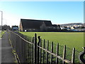
1
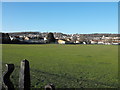
Baytree Rec
The recreation ground, looking towards Worlebury Hill.
Image: © Ant Basterfield
Taken: 1 Jan 2010
0.09 miles
2
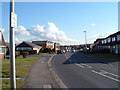
Suburban housing
Houses built in the 1960's on this large estate.
Image: © Ant Basterfield
Taken: 20 Feb 2010
0.10 miles
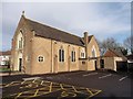
3
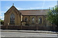
The Church of St Peter
This church is alongside the Baytree Road and faces south on to the Locking Road, while its right hand side adjoins Baytree Rec where football games are abounding on some days.
Image: © Ant Basterfield
Taken: 1 Jan 2010
0.11 miles
4
Our Lady of Lourdes, Catholic Church, Milton
Image: © Roger Cornfoot
Taken: 31 Jan 2018
0.13 miles
5

Interior, Our Lady of Lourdes, Catholic Church, Milton
Image: © Roger Cornfoot
Taken: 31 Jan 2018
0.13 miles
6
Our Lady of Lourdes Catholic Church, Weston-super-Mare
On Milton Road.
Image: © JThomas
Taken: 12 Jul 2019
0.13 miles
7
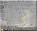
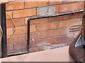
Ordnance Survey Cut Mark
This slightly damaged OS cut mark can be found on the church wall SE side of Milton Road. It marks a point 6.450m above mean sea level.
Image: © Adrian Dust
Taken: 13 Jul 2023
0.14 miles
8
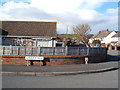
Road junction
Here is the junction of Garsdale Road and Corondale Road with a glimpse of Worlebury Hill the distance.
Image: © Ant Basterfield
Taken: 20 Feb 2010
0.14 miles
9
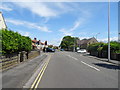
Milton Road, Weston-super-Mare
Junction with Baytree Road.
Image: © JThomas
Taken: 12 Jul 2019
0.16 miles
10
Ordnance Survey Cut Mark
This OS cut mark can be found on No3 Baytree Road. It marks a point 5.910m above mean sea level.
Image: © Adrian Dust
Taken: 13 Jul 2023
0.16 miles