IMAGES TAKEN NEAR TO
The Crescent, WESTON-SUPER-MARE, BS22 8DS
Introduction
This page details the photographs taken nearby to The Crescent, BS22 8DS by members of the Geograph project.
The Geograph project started in 2005 with the aim of publishing, organising and preserving representative images for every square kilometre of Great Britain, Ireland and the Isle of Man.

There are currently over 7.5m images from over14,400 individuals and you can help contribute to the project by visiting https://www.geograph.org.uk
Image Map (Loading...)


Getting Data...Please wait
Leaflet Map data © OpenStreetMap
Images are licensed for reuse under creativecommons.org/licenses/by-sa/2.0
Notes
- Clicking on the map will re-center to the selected point.
- The higher the marker number, the further away the image location is from the centre of the postcode.
Image Listing (21 Images Found)
Images are licensed for reuse under creativecommons.org/licenses/by-sa/2.0
Image
Details
Distance
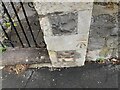
1
Ordnance Survey Cut Mark
This OS cut mark can be found on the wall of No47 Milton Park Road. It marks a point 22.138m above mean sea level.
Image: © Adrian Dust
Taken: 13 Jul 2023
0.07 miles
2
Ordnance Survey Cut Mark
This OS cut mark can be found on the wall of St Jude's Church. It marks a point 36.646m above mean sea level.
Image: © Adrian Dust
Taken: 13 Jul 2023
0.09 miles
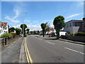
3

Baytree Road
Looking down Baytree Road
Image: © Adrian and Janet Quantock
Taken: 16 Oct 2005
0.13 miles
4

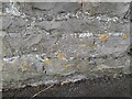
Ordnance Survey Cut Mark
This OS cut mark can be found on No88 Baytree Road. It marks a point 38.411m above mean sea level.
Image: © Adrian Dust
Taken: 13 Jul 2023
0.17 miles
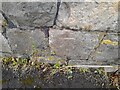
5
Ordnance Survey Bench Mark
Bench Mark located on the public conveniences in Ashcombe Park, Weston Super Mare. These marks were used by Ordnance Survey for mapping purposes.
Image: © V1ncenze
Taken: 18 Nov 2019
0.21 miles
7
Ordnance Survey Cut Mark
This OS cut mark can be found on the gatepost of No191 Milton Road. It marks a point 5.910m above mean sea level.
Image: © Adrian Dust
Taken: 13 Jul 2023
0.22 miles
9
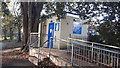
Public Conveniences, Ashcombe Park, Weston Super Mare
Image: © V1ncenze
Taken: 18 Nov 2019
0.22 miles
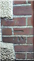
10
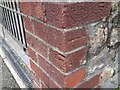
Ordnance Survey Cut Mark
This wall post on No58 Baytree Road has been rebuilt using original bricks. The OS cut mark is now in split and in an incorrect position, facing in two directions. It marked a point 19.8m above mean sea level.
Image: © Adrian Dust
Taken: 13 Jul 2023
0.22 miles