IMAGES TAKEN NEAR TO
Wick St. Lawrence, WESTON-SUPER-MARE, BS22 7YS
Introduction
This page details the photographs taken nearby to BS22 7YS by members of the Geograph project.
The Geograph project started in 2005 with the aim of publishing, organising and preserving representative images for every square kilometre of Great Britain, Ireland and the Isle of Man.

There are currently over 7.5m images from over14,400 individuals and you can help contribute to the project by visiting https://www.geograph.org.uk
Image Map
Images are licensed for reuse under creativecommons.org/licenses/by-sa/2.0
Notes
- Clicking on the map will re-center to the selected point.
- The higher the marker number, the further away the image location is from the centre of the postcode.
Image Listing (9 Images Found)
Images are licensed for reuse under creativecommons.org/licenses/by-sa/2.0
Image
Details
Distance
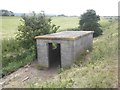
1
Wick St Lawrence sewage treatment works
Image: © Adrian and Janet Quantock
Taken: 25 Aug 2007
0.03 miles
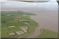
2
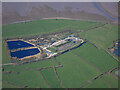
Wick St Lawrence sewage treatment works from the air
On the coast north of Wick St Lawrence.
Image: © Thomas Nugent
Taken: 7 Apr 2023
0.11 miles
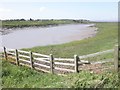
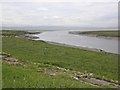
3
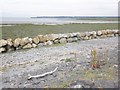
Coastal defences at the mouth of River Yeo
Image: © Roger Cornfoot
Taken: 24 Jun 2015
0.17 miles
6
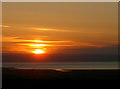
Sunset over the Yeo
Beacon Batch is the highest point for many miles around and takes in views over a fair bit of the South Wales mountains. Picked out by the rays of a fine sunset is the River Yeo as it runs into the Bristol Channel.
Image: © Neil Owen
Taken: 26 May 2017
0.20 miles
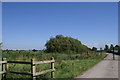
7
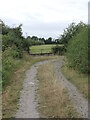
The end of Muddy Lane
Muddy Lane is a track across some of the flat fields near Wick St Lawrence and goes on a little further after this bend. However, the maps mark this as a restricted road which runs from Duck Lane but stops at this point. Another example of a public right of way that simply halts without connection.
Image: © Neil Owen
Taken: 21 Aug 2024
0.21 miles