IMAGES TAKEN NEAR TO
The Copse, WESTON-SUPER-MARE, BS22 7SL
Introduction
This page details the photographs taken nearby to The Copse, BS22 7SL by members of the Geograph project.
The Geograph project started in 2005 with the aim of publishing, organising and preserving representative images for every square kilometre of Great Britain, Ireland and the Isle of Man.

There are currently over 7.5m images from over14,400 individuals and you can help contribute to the project by visiting https://www.geograph.org.uk
Image Map
Images are licensed for reuse under creativecommons.org/licenses/by-sa/2.0
Notes
- Clicking on the map will re-center to the selected point.
- The higher the marker number, the further away the image location is from the centre of the postcode.
Image Listing (39 Images Found)
Images are licensed for reuse under creativecommons.org/licenses/by-sa/2.0
Image
Details
Distance
1
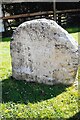
Old Milestone, Station Road, St George's
The milestone was originally located on Bristol Road and is now on Station Road, at the junction with Milestone Court, on the grass verge on the east side of the road. Parish of Weston Super Mare (North Somerset district). Carved stone post, Bristol old stone design, erected by the Bristol turnpike trust in the 18C.
Inscription reads: XVII / MILES FROM BRISTOL / TO WORLE
Milestone Society National ID: SO_BSWL17
Image: © Janet Dowding
Taken: 13 Apr 2009
0.10 miles
4
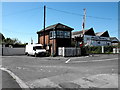
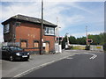
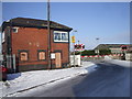
Ex Great Western signal box
Here is the old Great Western railway signal box in the small village of St Georges. The box had two main functions one to control the rail section towards the Worle junction (where originally was another box) and two for the operation of the level crossing gates before they became automated.
Image: © Ant Basterfield
Taken: 12 May 2012
0.11 miles
6
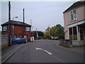
Level crossing in St Georges
Image: © Adrian and Janet Quantock
Taken: 16 Oct 2005
0.12 miles
8
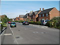
Willow Close houses, St Georges
Viewed from opposite a fenced-off area. http://www.geograph.org.uk/photo/3040755
Image: © Jaggery
Taken: 23 Jul 2011
0.15 miles
9
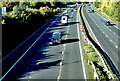
M5 northbound
Junction 21 - Weston-super-Mare
Image: © Anthony O'Neil
Taken: 10 Oct 2022
0.16 miles
10
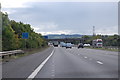
M5 near Junction 21
At marker 164.5 southbound.
Image: © J.Hannan-Briggs
Taken: 22 Sep 2015
0.16 miles