IMAGES TAKEN NEAR TO
Bramshill Drive, WESTON-SUPER-MARE, BS22 6UJ
Introduction
This page details the photographs taken nearby to Bramshill Drive, BS22 6UJ by members of the Geograph project.
The Geograph project started in 2005 with the aim of publishing, organising and preserving representative images for every square kilometre of Great Britain, Ireland and the Isle of Man.

There are currently over 7.5m images from over14,400 individuals and you can help contribute to the project by visiting https://www.geograph.org.uk
Image Map (Loading...)


Getting Data...Please wait
Leaflet Map data © OpenStreetMap
Images are licensed for reuse under creativecommons.org/licenses/by-sa/2.0
Notes
- Clicking on the map will re-center to the selected point.
- The higher the marker number, the further away the image location is from the centre of the postcode.
Image Listing (45 Images Found)
Images are licensed for reuse under creativecommons.org/licenses/by-sa/2.0
Image
Details
Distance
1
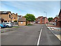
Rossendale Close looking North
Rossendale Close was built in 1987.
Image: © s
Taken: 18 May 2023
0.06 miles
4
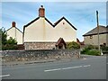
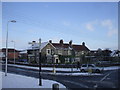
Medlar Cottage
Medlar Cottage was formerly the Crown Public House.
Image: © s
Taken: 18 May 2023
0.07 miles
6
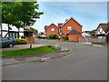
Ebdon Road
A modern housing estate with mock Tudor facades on some houses.
Image: © David Smith
Taken: 20 Apr 2012
0.07 miles
7
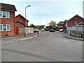
Site of Lynch Farm
Lynch Farm was demolished in 1987 and replaced with Rossendale Close.
Image: © s
Taken: 18 May 2023
0.08 miles
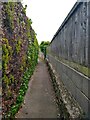
8
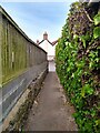
Footpath off Ebdon Road
Looking towards Medlar Cottage. Medlar Cottage was formerly the Crown Public House.
Image: © s
Taken: 18 May 2023
0.08 miles
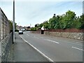
9
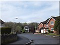
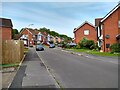
Savernake Road looking Northeast
Savernake Road was built in 1983.
Image: © s
Taken: 18 May 2023
0.08 miles
10
Savernake Road looking West
Savernake Road was built in 1983.
Image: © s
Taken: 18 May 2023
0.08 miles