IMAGES TAKEN NEAR TO
Constable Drive, WESTON-SUPER-MARE, BS22 6PU
Introduction
This page details the photographs taken nearby to Constable Drive, BS22 6PU by members of the Geograph project.
The Geograph project started in 2005 with the aim of publishing, organising and preserving representative images for every square kilometre of Great Britain, Ireland and the Isle of Man.

There are currently over 7.5m images from over14,400 individuals and you can help contribute to the project by visiting https://www.geograph.org.uk
Image Map
Images are licensed for reuse under creativecommons.org/licenses/by-sa/2.0
Notes
- Clicking on the map will re-center to the selected point.
- The higher the marker number, the further away the image location is from the centre of the postcode.
Image Listing (56 Images Found)
Images are licensed for reuse under creativecommons.org/licenses/by-sa/2.0
Image
Details
Distance
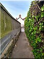
1
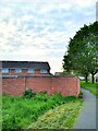
Rear of Constable Drive
Constable Drive was built in 1975.
Image: © s
Taken: 12 May 2023
0.05 miles
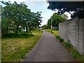
2
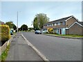
Madam Lane looking North
This section of Madam Lane from Hogarth Walk to the Queen's Way was built in 1975. The houses on the right were built in 1976.
Image: © s
Taken: 18 May 2023
0.06 miles
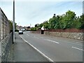
3
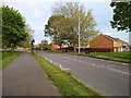
Queen's Way looking Southeast
This section of the Queen's Way from Bristol Road to Ebdon Road was built in 1977, with the other section from Ebdon Road to Lower Norton Lane being built in 1979.
Image: © s
Taken: 12 May 2023
0.07 miles
4
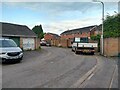
Hogarth Mews looking Northeast
Hogarth Mews was built in 1976.
Image: © s
Taken: 14 May 2023
0.08 miles
5
Footpath off Ebdon Road
Looking towards Medlar Cottage. Medlar Cottage was formerly the Crown Public House.
Image: © s
Taken: 18 May 2023
0.08 miles
7
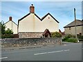
Medlar Cottage
Medlar Cottage was formerly the Crown Public House.
Image: © s
Taken: 18 May 2023
0.09 miles

9
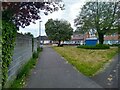
Hogarth Walk looking West
Hogarth Walk was built in 1976 on the old alignment of Madam Lane, which closed in motor traffic in 1979 up to Magdalen Way.
Looking towards houses on Madam Lane, which were built in 1975.
Image: © s
Taken: 14 May 2023
0.09 miles
10
Hogarth Walk looking Northeast
Hogarth Walk was built in 1976 on the old alignment of Madam Lane, which closed to motor traffic in 1979 up to Magdalen Way.
Image: © s
Taken: 14 May 2023
0.10 miles