IMAGES TAKEN NEAR TO
Court Place, WESTON-SUPER-MARE, BS22 6PN
Introduction
This page details the photographs taken nearby to Court Place, BS22 6PN by members of the Geograph project.
The Geograph project started in 2005 with the aim of publishing, organising and preserving representative images for every square kilometre of Great Britain, Ireland and the Isle of Man.

There are currently over 7.5m images from over14,400 individuals and you can help contribute to the project by visiting https://www.geograph.org.uk
Image Map
Images are licensed for reuse under creativecommons.org/licenses/by-sa/2.0
Notes
- Clicking on the map will re-center to the selected point.
- The higher the marker number, the further away the image location is from the centre of the postcode.
Image Listing (59 Images Found)
Images are licensed for reuse under creativecommons.org/licenses/by-sa/2.0
Image
Details
Distance
2
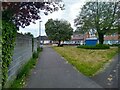
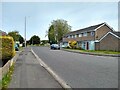
Hogarth Walk looking West
Hogarth Walk was built in 1976 on the old alignment of Madam Lane, which closed in motor traffic in 1979 up to Magdalen Way.
Looking towards houses on Madam Lane, which were built in 1975.
Image: © s
Taken: 14 May 2023
0.14 miles
3
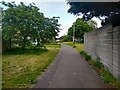
Hogarth Walk looking Northeast
Hogarth Walk was built in 1976 on the old alignment of Madam Lane, which closed to motor traffic in 1979 up to Magdalen Way.
Image: © s
Taken: 14 May 2023
0.14 miles
4
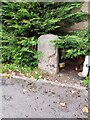
Boundary Stone, Laurel Farm
Boundary Stone dated 1853. Marked the boundary between Worle and Kewstoke parishes. Worle Parish has since been abolished and incorporated into Weston-super-Mare.
Image: © s
Taken: 10 Nov 2024
0.15 miles
5
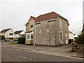
Laurel Farm, Station Road
Laurel Farm is a former 19th Century farmhouse, which later became a caravan park. The farmhouse is now studios.
Image: © s
Taken: 10 Nov 2024
0.15 miles
6

Hope Church, Worle
At the foot of The Scaurs, and partly illuminated by a lowering sun.
Image: © Derek Harper
Taken: 18 Oct 2016
0.15 miles
7
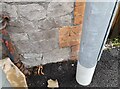
Ordnance Survey Cut Mark
This OS cut mark can be found on No1 The Scaurs.
Image: © Adrian Dust
Taken: 13 Jul 2023
0.15 miles
8
Madam Lane looking North
This section of Madam Lane from Hogarth Walk to the Queen's Way was built in 1975. The houses on the right were built in 1976.
Image: © s
Taken: 18 May 2023
0.15 miles
9
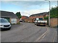
Hogarth Mews looking Northeast
Hogarth Mews was built in 1976.
Image: © s
Taken: 14 May 2023
0.15 miles