IMAGES TAKEN NEAR TO
Old Church Road, CLEVEDON, BS21 7UB
Introduction
This page details the photographs taken nearby to Old Church Road, BS21 7UB by members of the Geograph project.
The Geograph project started in 2005 with the aim of publishing, organising and preserving representative images for every square kilometre of Great Britain, Ireland and the Isle of Man.

There are currently over 7.5m images from over14,400 individuals and you can help contribute to the project by visiting https://www.geograph.org.uk
Image Map (Loading...)


Getting Data...Please wait
Leaflet Map data © OpenStreetMap
Images are licensed for reuse under creativecommons.org/licenses/by-sa/2.0
Notes
- Clicking on the map will re-center to the selected point.
- The higher the marker number, the further away the image location is from the centre of the postcode.
Image Listing (162 Images Found)
Images are licensed for reuse under creativecommons.org/licenses/by-sa/2.0
Image
Details
Distance
2
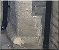
Ordnance Survey Cut Mark
This OS cut mark can be found on No167 Old Church Road. It marks a point 7.020m above mean sea level.
Image: © Adrian Dust
Taken: 26 Sep 2021
0.01 miles
3
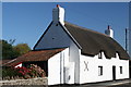
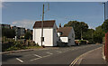
Whiteladies Cottage, 181 and 183 Old Church Road, Clevedon
Grade II Listed 17th century thatched cottage. Apparently a pair of single-unit dwellings that have been amalgamated to one house. The origins are unclear and the earliest part of the building is a fireplace, the remains of a building that no longer exists. The uniform 17th century roof and walls appear to be as a result of the extension of a 17th century house, extended to encompass an earlier surviving part. A planning application was made in 2012 to replace the cement render on the front with traditional breathable lime and horse-hair render. It was marketed in 2015 for £425,000 and sales particulars claim it was a former farmhouse enjoying the benefit of 37 acres.
Image: © Jo and Steve Turner
Taken: 17 Oct 2010
0.03 miles
4
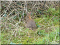
Biological Construction
Rabbit at work collecting sticks off Wains Hill North hillock. Assumed it was camouflaged in the brush and so continued during photography.
Image: © MDS
Taken: 20 Feb 2007
0.05 miles
5
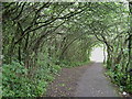
Tunnel of Goat Willow, south-east side of Church Hill, Clevedon
Image: © Robin Stott
Taken: 10 Jun 2009
0.07 miles
6
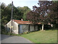
Block on Old Church Road
This area was a quarry until the early part of the twentieth century. The present block looks about WWII era.
Image: © Neil Owen
Taken: 21 Sep 2021
0.07 miles
8

Memorials, St Andrew's Church graveyard
Image: © Nick Barber
Taken: 14 Aug 2020
0.10 miles
9
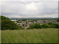
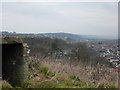
Descending Church Hill, Clevedon
Looking across the western suburbs of Clevedon.
Image: © Robin Stott
Taken: 10 Jun 2009
0.11 miles
10
West End
A view of south west Clevedon, from Wain's Hill
Image: © Peter Barr
Taken: 7 Feb 2010
0.11 miles