IMAGES TAKEN NEAR TO
Salthouse Road, CLEVEDON, BS21 7TT
Introduction
This page details the photographs taken nearby to Salthouse Road, BS21 7TT by members of the Geograph project.
The Geograph project started in 2005 with the aim of publishing, organising and preserving representative images for every square kilometre of Great Britain, Ireland and the Isle of Man.

There are currently over 7.5m images from over14,400 individuals and you can help contribute to the project by visiting https://www.geograph.org.uk
Image Map (Loading...)


Getting Data...Please wait
Leaflet Map data © OpenStreetMap
Images are licensed for reuse under creativecommons.org/licenses/by-sa/2.0
Notes
- Clicking on the map will re-center to the selected point.
- The higher the marker number, the further away the image location is from the centre of the postcode.
Image Listing (180 Images Found)
Images are licensed for reuse under creativecommons.org/licenses/by-sa/2.0
Image
Details
Distance
2
The Salthouse Clevedon
Below Church Hill
Image: © norman griffin
Taken: 28 Jul 2007
0.04 miles
3
Ordnance Survey Cut Mark
This OS cut mark can be found on the gatepost of The Salthouse PH. It marks a point 6.800m above mean sea level.
Image: © Adrian Dust
Taken: 26 Sep 2021
0.05 miles
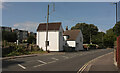
4
Steps to The Salthouse, Clevedon
Mid 19th century pub and restaurant viewed from Salthouse Road at the edge of Salthouse Bay.
Image: © Jaggery
Taken: 14 Apr 2014
0.05 miles
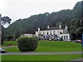
5
The Salthouse
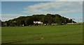
Seen across Salthouse Fields with the miniature railway track in the foreground. the dark timber shed right of centre is where you buy your tickets for the railway. The white stucco Salthouse is now a pub, listed and described at https://www.historicengland.org.uk/listing/the-list/list-entry/1129698 . http://clevedonspotlight.co.uk/index.php/clevedon-history/the-salthouse suggests that the building was originally a pair of cottages used by salt workers; the Fields were used for the manufacture of sea salt. Behind the pub is the wooded Church Hill.
Image: © Derek Harper
Taken: 22 Sep 2017
0.05 miles
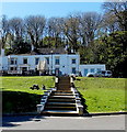
6
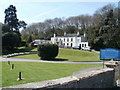
Clevedon, The Salthouse
Overlooking Salthouse Bay, the site of salt pans, and previously a private residence. Internally, U-shaped bar, with drinking & eating areas to left & right. Cask ales on offer at my visit: Skinners Betty Stoggs, Butcombe Bitter, Sharp's Doom Bar. For customer comments, see http://www.beerintheevening.com/pubs/s/40/40004/Salthouse/Clevedon
Image: © Mike Faherty
Taken: 21 Apr 2010
0.06 miles
7
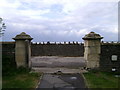
Gate pillars, Salthouse Fields, Clevedon
One way of reaching the promenade from the car park is to ignore the main path and instead pass between these handsome limestone gate pillars. Big shower clouds sweep across South Wales on the other side of the Bristol Channel.
Image: © Robin Stott
Taken: 10 Jun 2009
0.06 miles
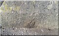
8
Ordnance Survey Cut Mark
This OS cut mark can be found on The Salthouse PH. It marks a point 12.280m above mean sea level.
Image: © Adrian Dust
Taken: 26 Sep 2021
0.06 miles
9
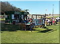
Snack bar in Salthouse Fields, Clevedon
Salthouse Fields is a coastal recreation area at the edge of Salthouse Bay.
The sea wall is in the background.
Image: © Jaggery
Taken: 14 Apr 2014
0.06 miles
10
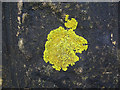
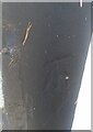
Lichen
North facing sea wall lichen, enlarged shows the detail, 0.8 metre above the Lake Tribulation walkway at Clevedon Marine. Now into Phase III of the Rivers Division seawall "development".
Image: © MDS
Taken: 20 Feb 2007
0.07 miles