IMAGES TAKEN NEAR TO
Queens Road, CLEVEDON, BS21 7TF
Introduction
This page details the photographs taken nearby to Queens Road, BS21 7TF by members of the Geograph project.
The Geograph project started in 2005 with the aim of publishing, organising and preserving representative images for every square kilometre of Great Britain, Ireland and the Isle of Man.

There are currently over 7.5m images from over14,400 individuals and you can help contribute to the project by visiting https://www.geograph.org.uk
Image Map (Loading...)


Getting Data...Please wait
Leaflet Map data © OpenStreetMap
Images are licensed for reuse under creativecommons.org/licenses/by-sa/2.0
Notes
- Clicking on the map will re-center to the selected point.
- The higher the marker number, the further away the image location is from the centre of the postcode.
Image Listing (227 Images Found)
Images are licensed for reuse under creativecommons.org/licenses/by-sa/2.0
Image
Details
Distance
1

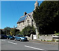
Former Clevedon Police Station
Viewed in April 2014. This building, on the corner of Queen's Road and Sunnyside Road, used to be the town's police station. A ghost of the removed red dragon symbol can be seen on the wall.
Out of shot, a notice shows that from January 2nd 2013, police enquiries have been dealt with at Castlewood in partnership with North Somerset Council. Castlewood is on Tickenham Road in the old Clerical Medical building.
Image: © Jaggery
Taken: 14 Apr 2014
0.03 miles
2
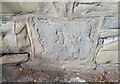
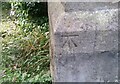
Ordnance Survey Cut Mark
This damaged OS cut mark can be found on the wall north side of Sunnyside Road. It marks a point 20.477m above mean sea level.
Image: © Adrian Dust
Taken: 25 Sep 2021
0.03 miles
3
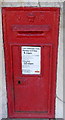
Letterbox on Queen's Road, Clevedon
A Victorian variety. See Image] for a location view.
Image: © Neil Owen
Taken: 31 Aug 2020
0.03 miles
4
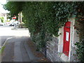
Posting a letter on Queen's Road
See Image] for a closer look at the period letterbox.
Image: © Neil Owen
Taken: 31 Aug 2020
0.03 miles
5
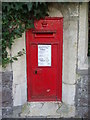
Queen Victoria postbox, Queen's Road, Clevedon
In a wall near the corner of St John's Road. The last collection from this box
is shown to be at 5.30pm on Mondays-Fridays. If you miss the last collection,
you have less than 30 minutes to get to Clevedon Delivery Office http://www.geograph.org.uk/photo/4077515
in Albert Road, where the last collection is stated to be at 6pm.
The last Saturday collection here is shown to be at 12.45pm.
No later Saturday collection time is shown for the delivery office.
Image: © Jaggery
Taken: 14 Apr 2014
0.04 miles
6
Solar panels, St John's Vicarage, Clevedon
Viewed across St John's Road from the corner of Queen's Road.
The vicarage is opposite the Parish Church of St John the Evangelist. http://www.geograph.org.uk/photo/4150132
Image: © Jaggery
Taken: 14 Apr 2014
0.04 miles
7
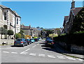
Madeira Road, Clevedon
Viewed across Queen's Road. In the distance, the course of Madeira Road
turns through about 90 degrees, to the left.
Image: © Jaggery
Taken: 14 Apr 2014
0.04 miles
8
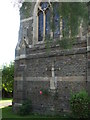
The east end of St John's church
A rose provides a spot of colour. Down by the lower buttress is a benchmark - see Image
Image: © Neil Owen
Taken: 31 Aug 2020
0.06 miles
9
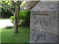
Benchmark on St John's, Clevedon
A nineteenth century cutmark, as listed in the Benchmark Database: https://www.bench-marks.org.uk/bm97837 , on the east angle of the church. See Image] for a wider view.
Image: © Neil Owen
Taken: 31 Aug 2020
0.06 miles
10
Ordnance Survey Cut Mark
This OS cut mark can be found on St John's Church. It marks a point 11.137m above mean sea level.
Image: © Adrian Dust
Taken: 25 Sep 2021
0.06 miles