IMAGES TAKEN NEAR TO
Sunnyside Road, CLEVEDON, BS21 7TA
Introduction
This page details the photographs taken nearby to Sunnyside Road, BS21 7TA by members of the Geograph project.
The Geograph project started in 2005 with the aim of publishing, organising and preserving representative images for every square kilometre of Great Britain, Ireland and the Isle of Man.

There are currently over 7.5m images from over14,400 individuals and you can help contribute to the project by visiting https://www.geograph.org.uk
Image Map (Loading...)


Getting Data...Please wait
Leaflet Map data © OpenStreetMap
Images are licensed for reuse under creativecommons.org/licenses/by-sa/2.0
Notes
- Clicking on the map will re-center to the selected point.
- The higher the marker number, the further away the image location is from the centre of the postcode.
Image Listing (175 Images Found)
Images are licensed for reuse under creativecommons.org/licenses/by-sa/2.0
Image
Details
Distance
1
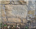
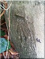
Ordnance Survey Cut Mark
This OS cut mark can be found on the wall east side of Sunnyside Road. It marks a point 29.599m above mean sea level.
Image: © Adrian Dust
Taken: 25 Sep 2021
0.01 miles
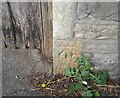
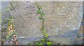
2
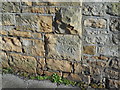
An OS Bench Mark
A clear cut mark on a gatepost.
Image: © Anthony Vosper
Taken: 8 Feb 2020
0.02 miles
3
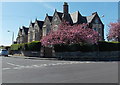
Gables and spring blossom in Coleridge Road, Clevedon
Viewed in mid-April 2014.
Image: © Jaggery
Taken: 14 Apr 2014
0.04 miles
4
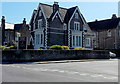
Grendon Lodge Dental Practice in Clevedon
At 22 St John's Road, on the corner of Coleridge Road.
Image: © Jaggery
Taken: 14 Apr 2014
0.05 miles
5
Ordnance Survey Cut Mark
This OS cut mark can be found on the gatepost of No16 Albert Road. It marks a point 30.846m above mean sea level.
Image: © Adrian Dust
Taken: 25 Sep 2021
0.07 miles
6
Ordnance Survey Cut Mark
This OS cut mark can be found on the wall north side of Sunnyside Road. It marks a point 22.089m above mean sea level.
Image: © Adrian Dust
Taken: 25 Sep 2021
0.08 miles
7
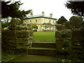
Princes Road Community Centre from Sunnyside Road
Image: © Dave Beynon
Taken: 3 Dec 2002
0.08 miles
8
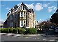
Waverley Lodge, Clevedon
Residential care home at 17 Albert Road, on the corner of Princes Road.
Image: © Jaggery
Taken: 14 Apr 2014
0.09 miles
9

Ordnance Survey Cut Mark
This OS cut mark can be found on the wall of No21 Victoria Road. It marks a point 19.799m above mean sea level.
Image: © Adrian Dust
Taken: 25 Sep 2021
0.09 miles
10
Ordnance Survey Cut Mark
This OS cut mark can be found on the gatepost of Sunhill Park, Princes Road. It marks a point 33.562m above mean sea level.
Image: © Adrian Dust
Taken: 25 Sep 2021
0.09 miles