IMAGES TAKEN NEAR TO
Lower Linden Road, CLEVEDON, BS21 7SU
Introduction
This page details the photographs taken nearby to Lower Linden Road, BS21 7SU by members of the Geograph project.
The Geograph project started in 2005 with the aim of publishing, organising and preserving representative images for every square kilometre of Great Britain, Ireland and the Isle of Man.

There are currently over 7.5m images from over14,400 individuals and you can help contribute to the project by visiting https://www.geograph.org.uk
Image Map (Loading...)


Getting Data...Please wait
Leaflet Map data © OpenStreetMap
Images are licensed for reuse under creativecommons.org/licenses/by-sa/2.0
Notes
- Clicking on the map will re-center to the selected point.
- The higher the marker number, the further away the image location is from the centre of the postcode.
Image Listing (226 Images Found)
Images are licensed for reuse under creativecommons.org/licenses/by-sa/2.0
Image
Details
Distance
1
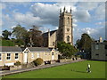
A quiet corner of Clevedon
Somewhere near the middle of the seaside town is the Clevedon Bowling Club and, peering over its shoulder, is Christchurch. A solitary bowler takes a moment or two to perfect his game in the afternoon sunshine.
Image: © Neil Owen
Taken: 31 Aug 2020
0.04 miles
2
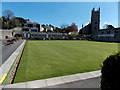
Clevedon Bowling Club
Viewed from Princes Road looking towards Christchurch. http://www.geograph.org.uk/photo/4181035
Image: © Jaggery
Taken: 14 Apr 2014
0.04 miles
3
Half mast for a local legend
The flag at Clevedon Bowling Club flies gently at half mast in honour of the recently departed David Bryant CBE. He was perhaps the most recognised and successful bowler in the country and was a member here.
Clevedon Bowling Club was formed in 1910, originally based in Linden Road. But before the year was out they moved to the present ground.
Image: © Neil Owen
Taken: 31 Aug 2020
0.05 miles
4
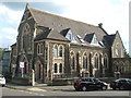
The former Linden Road church
This grand building was the Wesleyan Methodist church up until about 2005, whereafter the church merged with Christ Church and left it. The old church was renovated and is now residential properties.
When it was being built in the late 1800s, workers digging the foundations discovered pottery and coins - as was the case in nearby places around that time of expansion.
Image: © Neil Owen
Taken: 31 Aug 2020
0.05 miles
5

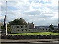
A green corner of Clevedon
Trees dominate the corner of Princes Road (on the left) and Linden Road.
Image: © Jaggery
Taken: 14 Apr 2014
0.05 miles
6
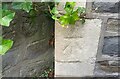
Ordnance Survey Cut Mark
This OS cut mark can be found on the Chapel on Lower Lindon Road. It marks a point 27.249m above mean sea level.
Image: © Adrian Dust
Taken: 25 Sep 2021
0.05 miles
7
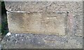
Ordnance Survey Cut Mark
This worn OS cut mark can be found on Christ Church. It marks a point 41.258m above mean sea level.
Image: © Adrian Dust
Taken: 25 Sep 2021
0.05 miles
8
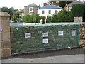
The Prayer Wall
Clevedon's Christ Church has made this outer wall somewhere to pray and tie a written version to it.
Image: © Neil Owen
Taken: 31 Aug 2020
0.06 miles
9
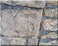
Ordnance Survey Cut Mark
This very worn OS cut mark can be found on the wall east side of Chapel Hill. It marks a point 102.0ft above mean sea level.
Image: © Adrian Dust
Taken: 25 Sep 2021
0.06 miles
10
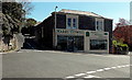
Harry Powell, Clevedon
Kitchens, bedrooms and bathrooms shop on the corner of Hill Road and Park Road.
Image: © Jaggery
Taken: 14 Apr 2014
0.06 miles