IMAGES TAKEN NEAR TO
Albert Road, CLEVEDON, BS21 7RP
Introduction
This page details the photographs taken nearby to Albert Road, BS21 7RP by members of the Geograph project.
The Geograph project started in 2005 with the aim of publishing, organising and preserving representative images for every square kilometre of Great Britain, Ireland and the Isle of Man.

There are currently over 7.5m images from over14,400 individuals and you can help contribute to the project by visiting https://www.geograph.org.uk
Image Map (Loading...)


Getting Data...Please wait
Leaflet Map data © OpenStreetMap
Images are licensed for reuse under creativecommons.org/licenses/by-sa/2.0
Notes
- Clicking on the map will re-center to the selected point.
- The higher the marker number, the further away the image location is from the centre of the postcode.
Image Listing (215 Images Found)
Images are licensed for reuse under creativecommons.org/licenses/by-sa/2.0
Image
Details
Distance
2
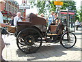
Clevedon - Queen's Square
A 1898 R.J.Stephens Car. This car was built in Clevedon within about 50 yards of this photo.
Image: © Ian Knox
Taken: 8 Jul 2006
0.02 miles
3
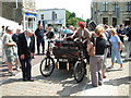
Clevedon - Station Road
The Motor car in the foreground is a 1898 R.J.Stephens. The car was built in Clevedon Motor Car and Engineering Works now the St. Peter's Hospice shop seen in the background behind the car.
Image: © Ian Knox
Taken: 8 Jul 2006
0.02 miles
4
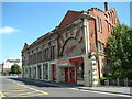
Clevedon - The Curzon Community Cinema, Old Church Road
The oldest, purpose-built, continuously operated cinema in the World
http://www.curzon.org.uk/
Image: © Ian Knox
Taken: 9 Jul 2006
0.02 miles
5
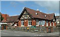
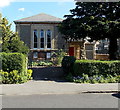
Clevedon - Library
The building used to be St.John's School. The school was moved to a new building and the old school converted into the town library
http://www.n-somerset.gov.uk/Leisure/Libraries/Libraries/clevedonlibrary.htm
Image: © Ian Knox
Taken: 9 Jul 2006
0.02 miles
6
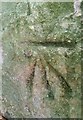
Ordnance Survey Cut Mark
This OS cut mark can be found on the gatepost of the Friends Meeting House on Albert Road. It marks a point 30.319m above mean sea level.
Image: © Adrian Dust
Taken: 25 Sep 2021
0.02 miles
7
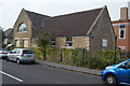
Clevedon ACF Drill Hall
Pre-WW1 drill hall used by North Somerset Yeomanry and Royal Engineers in 1914.
Image: © John M
Taken: 5 Sep 2014
0.02 miles
8
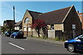
Clevedon Cadet Centre
On the corner of Hallam Road and Albert Road, Clevedon Cadet Centre is home to 1446 (Clevedon) Squadron Air Training Corps and the Somerset Army Cadet Force Clevedon Detachment.
Image: © Jaggery
Taken: 14 Apr 2014
0.02 miles
9
Quaker Meeting House, Clevedon
The Quaker Meeting House (or Society of Friends Meeting House) is in Albert Road.
Image: © Jaggery
Taken: 14 Apr 2014
0.03 miles
10
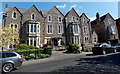
Winash, Clevedon
Winash in Albert Road has been a residential care home for the elderly since 1938.
Image: © Jaggery
Taken: 14 Apr 2014
0.03 miles