IMAGES TAKEN NEAR TO
Wellington Terrace, CLEVEDON, BS21 7PY
Introduction
This page details the photographs taken nearby to Wellington Terrace, BS21 7PY by members of the Geograph project.
The Geograph project started in 2005 with the aim of publishing, organising and preserving representative images for every square kilometre of Great Britain, Ireland and the Isle of Man.

There are currently over 7.5m images from over14,400 individuals and you can help contribute to the project by visiting https://www.geograph.org.uk
Image Map
Images are licensed for reuse under creativecommons.org/licenses/by-sa/2.0
Notes
- Clicking on the map will re-center to the selected point.
- The higher the marker number, the further away the image location is from the centre of the postcode.
Image Listing (224 Images Found)
Images are licensed for reuse under creativecommons.org/licenses/by-sa/2.0
Image
Details
Distance
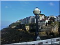
2
High Cliff, Clevedon
Seen from the pier.
Image: © Jonathan Thacker
Taken: 26 Sep 2021
0.03 miles
3
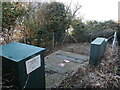
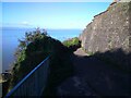
Pumping station by the coast path
Located by the narrow coast path on the cliffs is a pumping station. It is perched right by the drop.
Image: © Neil Owen
Taken: 27 Oct 2024
0.03 miles
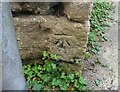
4
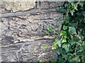
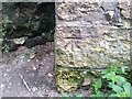
Ordnance Survey Cut Mark
This OS cut mark can be found on the wall of the Stancliffe Flats SE side of Wellington Terrace. It marks a point 39.533m above mean sea level.
Image: © Adrian Dust
Taken: 25 Sep 2021
0.03 miles
5
Footpath to Ladye Bay
I discovered this footpath, which leads quite a way towards Portishead.
Image: © Ant Basterfield
Taken: 4 Nov 2020
0.04 miles
6
Ordnance Survey Cut Mark
This OS cut mark can be found on the wall east side of the footpath. It marks a point 27.987m above mean sea level.
Image: © Adrian Dust
Taken: 25 Sep 2021
0.04 miles
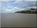
8
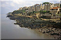
Clevedon shoreline
From the pier looking north-east along the shoreline. Houses on Wellington Terrace overlook the sea. Ladye Point in the distance.
Image: © Trevor Rickard
Taken: Unknown
0.05 miles
9
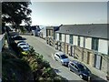
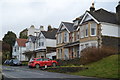
Some very smart properties in this road
Not sure if they were always houses here and then modernised or these are newly built properties.
Image: © Ant Basterfield
Taken: 4 Nov 2020
0.07 miles
10
Ordnance Survey Cut Mark
This OS cut mark can be found on the wall of No10 Wellington Terrace. It marks a point 39.583m above mean sea level.
Image: © Adrian Dust
Taken: 25 Sep 2021
0.07 miles