IMAGES TAKEN NEAR TO
Hill Road, CLEVEDON, BS21 7PN
Introduction
This page details the photographs taken nearby to Hill Road, BS21 7PN by members of the Geograph project.
The Geograph project started in 2005 with the aim of publishing, organising and preserving representative images for every square kilometre of Great Britain, Ireland and the Isle of Man.

There are currently over 7.5m images from over14,400 individuals and you can help contribute to the project by visiting https://www.geograph.org.uk
Image Map
Images are licensed for reuse under creativecommons.org/licenses/by-sa/2.0
Notes
- Clicking on the map will re-center to the selected point.
- The higher the marker number, the further away the image location is from the centre of the postcode.
Image Listing (301 Images Found)
Images are licensed for reuse under creativecommons.org/licenses/by-sa/2.0
Image
Details
Distance
1
Corner of Copse Road and Marine Hill, Clevedon
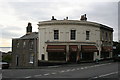
The former chemist's established in 1837, The Cellar Lounge was incorporated in 2007 and is 36 Hill Road, the shop front being a unique survival in Clevedon. Along with 36, on the left 51 Copse Road and 51a Christiana form a group of early 19th century Grade II Listed buildings. Adjoining on the right and also Grade II Listed are later, probably mid 19th century, 1 Marine Hill and 36 Hill Road.
Image: © Jo and Steve Turner
Taken: 15 Oct 2010
0.03 miles
2
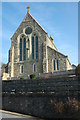
Franciscan Friary in Clevedon
The Franciscan Friary and Parish Church of the Immaculate Conception is situated on high ground overlooking the Bristol Channel.
Image: © Philip Halling
Taken: 13 Mar 2010
0.03 miles
3
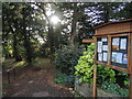
Top entrance to Alexandra Gardens
A small but well-stocked public park in Clevedon, it was gifted to the town by local magnate Sir Arthur Elton of Clevedon Court in the mid-1800s. The bandstand is no longer there but there are a great many mature tree species.
Image: © Neil Owen
Taken: 28 Oct 2022
0.03 miles
4
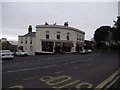
The cellar Lounge
Situated on the junction of Hill and Copse Road.
Now a tea room and wine bar.
Originally this was a chemist's shop.
Some of the original features have been retained inside.
Image: © Anthony Vosper
Taken: 9 Dec 2014
0.03 miles
5
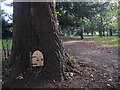
Is anyone home?
A little door for a little person in Alexandra Gardens.
Image: © Neil Owen
Taken: 28 Oct 2022
0.05 miles
6
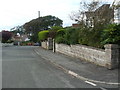
Junction of Dial Hill Road and Castle View Road
A quiet suburban part of Clevedon. On the nearest pillar is a benchmark - see Image
Image: © Neil Owen
Taken: 31 Aug 2020
0.05 miles
7
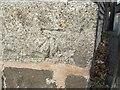
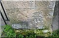
Benchmark on Dial Hill Road
A modern mark on a modern (post-war) part of suburban Clevedon. See https://www.bench-marks.org.uk/bm132926 for the entry in the Benchmark Database and Image] for a wider view.
Image: © Neil Owen
Taken: 31 Aug 2020
0.05 miles
8
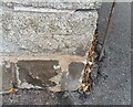
Ordnance Survey Cut Mark
This OS cut mark can be found on the wall at the junction of Dial Hill Road & Castle View Road. It marks a point 59.741m above mean sea level.
Image: © Adrian Dust
Taken: 25 Sep 2021
0.05 miles
9
The Regent, 24 Hill Road, Clevedon
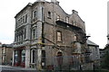
Built in 1857 by local businessman, baker and confectioner John Maynard the shop was originally a bakery and later a delicatessen. Reportedly by the 1880s it was an inn and restaurant and after 1945 a hotel and then public house that closed in 2005. However in 1897-1902 Alfred B Wickenden Confectioner is listed at 26 Hill Road and in 1914-1919 John Ward Dawkins Confectioner. Prior to this there are no street numbers but in 1889 there are two or three confectioners, one being Edward Seagrave baker & confectioner listed at Hillwood House? It was converted at a reported cost of £5.2m (although Construction Total Solutions Ltd say their contract was £2.6m) to 20 apartments in 2014 by architects O'Leary Goss for Freemantle Developments and was completed in July 2015 with 5,700 sq.ft. of retail space let to Sainsbury's Ltd. and Fizz Gallery and Framing who have been there since at least July 2016.
Image: © Jo and Steve Turner
Taken: 15 Oct 2010
0.06 miles
10
Ordnance Survey Cut Mark
This OS cut mark can be found on the gatepost south side of Marine Hill. It marks a point 35.491m above mean sea level.
Image: © Adrian Dust
Taken: 25 Sep 2021
0.06 miles