IMAGES TAKEN NEAR TO
Bellevue Road, CLEVEDON, BS21 7NU
Introduction
This page details the photographs taken nearby to Bellevue Road, BS21 7NU by members of the Geograph project.
The Geograph project started in 2005 with the aim of publishing, organising and preserving representative images for every square kilometre of Great Britain, Ireland and the Isle of Man.

There are currently over 7.5m images from over14,400 individuals and you can help contribute to the project by visiting https://www.geograph.org.uk
Image Map (Loading...)


Getting Data...Please wait
Leaflet Map data © OpenStreetMap
Images are licensed for reuse under creativecommons.org/licenses/by-sa/2.0
Notes
- Clicking on the map will re-center to the selected point.
- The higher the marker number, the further away the image location is from the centre of the postcode.
Image Listing (215 Images Found)
Images are licensed for reuse under creativecommons.org/licenses/by-sa/2.0
Image
Details
Distance
1

Clevedon from the Zig-zag
The road above Hill Road is particularly steep and the path has to change direction a number of times. However, the efforts scaling it are rewarded by this view over central Clevedon.
Image: © Neil Owen
Taken: 31 Aug 2020
0.03 miles
2

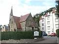
United Reformed Church, Hill Road, Clevedon
Grade II Listed Church of 1855 by Foster and Ward, Bristol. Falling attendances and increasing maintenance expenses forced the sale of the Church, and it is now Chysauster retirement flats completed in 1991. From 1984 the United Reformed Church shared St. Peter's Church in Alexandra Road with the Anglican Congregation.
Image: © Jo and Steve Turner
Taken: 15 Oct 2010
0.04 miles
3

Burstead House, 39 Hill Road, Clevedon
Jacobean style Grade II Listed mid 19th century house. It sold for £565,000 in November 2012.
Image: © Jo and Steve Turner
Taken: 15 Oct 2010
0.04 miles
4

Burstead House Clevedon
Grade II listed, Burstead house is situated on Hill Road next to the former United Reformed Church which has now been converted into flats. The house was built in the mid 19C in the Jacobean style and was once the home of the Reverend Fothergill, curate of St Andrew's Church.
Image: © Sarah Smith
Taken: 11 Feb 2019
0.04 miles
5
The former Congregational Chapel on Hill Road
Founded in 1885 to designs by Foster & Wood of Bristol, the Congregational Chapel later became part of the United Reformed Church. Its noticeable feature is the slender octagonal bell-tower surmounted by a shafted lantern with steep conical roof. Interestingly the O.S. maps currently list it as a mere 'cross' but not very long ago it was a 'church with spire'. The falling attendances forced the church to close in the 1990s and it was converted into residential use.
Image: © Neil Owen
Taken: 31 Aug 2020
0.04 miles
6
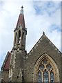
Is it a spire or not?
The former Congregational Chapel's slender octagonal bell-tower is surmounted by a shafted lantern with a steep conical roof. Although not a church anymore (it was converted to residential use decades ago) the O.S. used to mark it as a 'church with spire'. But not now - it's just a mere 'cross' symbol.
Image: © Neil Owen
Taken: 31 Aug 2020
0.04 miles
7

Growing in the gutter
Some soil must have found its way into the system.
Image: © Neil Owen
Taken: 28 Oct 2022
0.05 miles
8

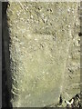
Forgotten benchmark on Hill Road
The badly-covered remnants of a cutmark can just about be discerned on the corner of a bar in Hill Street. See https://www.bench-marks.org.uk/bm180031 for the entry in the Benchmark Database for this lost mark.
Image: © Neil Owen
Taken: 28 Oct 2022
0.05 miles
9

14 and 16, Malvern House, Hill Road, Clevedon
Grade II Listed Malvern House became Junior Poon's Chinese Restaurant in 1992 in the former pharmacists built in 1845 by Sir Arthur Hallam Elton. The oil street lamp (out of shot) in front of the building was one of the first outside London. Prior to 1883 the chemist was Frederick Martin (1842-1883) succeeded by Thomas Grant until 1899 (when he turned to selling cars and cycles) and then From 1903 to 1931 Henry Shepherd. Boots were last to run a chemists from here. Interestingly both Martin and Grant sold microscopic slides on the side and in the 1881 census Grant is listed as 'visitor' at Malvern House so presumably learning his slide skills from Martin and taking over the business on his death.
Image: © Jo and Steve Turner
Taken: 15 Oct 2010
0.07 miles
10
Ordnance Survey Cut Mark
This OS cut mark can be found on the wall of No25 Hill Road. Newton House. It marks a point 41.803m above mean sea level.
Image: © Adrian Dust
Taken: 14 Mar 2016
0.08 miles