IMAGES TAKEN NEAR TO
Edward Road South, CLEVEDON, BS21 7HZ
Introduction
This page details the photographs taken nearby to Edward Road South, BS21 7HZ by members of the Geograph project.
The Geograph project started in 2005 with the aim of publishing, organising and preserving representative images for every square kilometre of Great Britain, Ireland and the Isle of Man.

There are currently over 7.5m images from over14,400 individuals and you can help contribute to the project by visiting https://www.geograph.org.uk
Image Map (Loading...)


Getting Data...Please wait
Leaflet Map data © OpenStreetMap
Images are licensed for reuse under creativecommons.org/licenses/by-sa/2.0
Notes
- Clicking on the map will re-center to the selected point.
- The higher the marker number, the further away the image location is from the centre of the postcode.
Image Listing (22 Images Found)
Images are licensed for reuse under creativecommons.org/licenses/by-sa/2.0
Image
Details
Distance
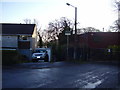
1
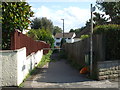
To Bennett's Ripple
The footpath on Edward Road South leads down Bennett's Ripple to the school.
Image: © Neil Owen
Taken: 31 Aug 2020
0.04 miles
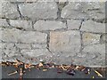
2
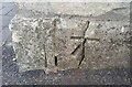
Ordnance Survey Cut Mark
This OS cut mark can be found on the wall of No16 Edward Road. It marks a point 58.982m above mean sea level.
Image: © Adrian Dust
Taken: 25 Sep 2021
0.06 miles
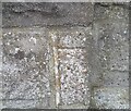
3
Ordnance Survey Cut Mark
This OS cut mark can be found on the wall of No27 Cambridge Road. It marks a point 61.527m above mean sea level.
Image: © Adrian Dust
Taken: 3 Aug 2022
0.09 miles
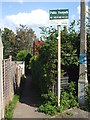
5
Footpath to Strawberry Hill
Situated off Rippleside Road.
Most of the neighbouring housing estate was built in the late 1960's.
Note the out of character wooden framed house on the right.
Image: © Anthony Vosper
Taken: 21 Feb 2014
0.15 miles
6
Path to Strawberry Hill
No motorcycles! The sign, however, refers to the long-defunct District of Woodspring that closed in 1997.
Image: © Neil Owen
Taken: 31 Aug 2020
0.15 miles
7
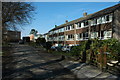
Houses in Walton St Mary
Sixties style housing at Walton St Mary, Clevedon.
Image: © Philip Halling
Taken: 13 Mar 2010
0.15 miles
8
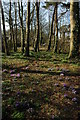
Crocuses on Dial Hill
Crocuses among the trees on Dial Hill, Clevedon.
Image: © Philip Halling
Taken: 13 Mar 2010
0.16 miles
9
Ordnance Survey Cut Mark
This damaged OS cut mark can be found on the gatepost of No3 The Avenue. It marks a point 174.5ft above mean sea level.
Image: © Adrian Dust
Taken: 25 Sep 2021
0.18 miles
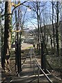
10
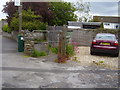
Old Park Road footpath
The path provides a link to Rippleside Road.
There is a benchmark low on the gatepost.
Image: © Anthony Vosper
Taken: 8 Jun 2015
0.18 miles