IMAGES TAKEN NEAR TO
Dial Hill Road, CLEVEDON, BS21 7HJ
Introduction
This page details the photographs taken nearby to Dial Hill Road, BS21 7HJ by members of the Geograph project.
The Geograph project started in 2005 with the aim of publishing, organising and preserving representative images for every square kilometre of Great Britain, Ireland and the Isle of Man.

There are currently over 7.5m images from over14,400 individuals and you can help contribute to the project by visiting https://www.geograph.org.uk
Image Map
Images are licensed for reuse under creativecommons.org/licenses/by-sa/2.0
Notes
- Clicking on the map will re-center to the selected point.
- The higher the marker number, the further away the image location is from the centre of the postcode.
Image Listing (65 Images Found)
Images are licensed for reuse under creativecommons.org/licenses/by-sa/2.0
Image
Details
Distance
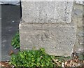
1
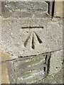
Ordnance Survey Cut Mark
This OS cut mark can be found on No6 Dial Hill Road. It marks a point 65.145m above mean sea level.
Image: © Adrian Dust
Taken: 25 Sep 2021
0.02 miles
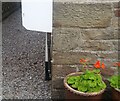
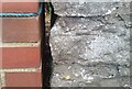
2
Park Road Bench Mark
An OS cut mark on a wall.
Image: © Anthony Vosper
Taken: 4 Jun 2015
0.05 miles
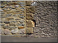
3
Ordnance Survey Cut Mark
This OS cut mark can be found on the wall east side of Park Road. It marks a point 62.597m above mean sea level.
Image: © Adrian Dust
Taken: 25 Sep 2021
0.06 miles
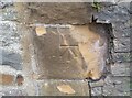
4
Ordnance Survey Cut Mark
This OS cut mark can be found on the gatepost of No5 Park Road. It marks a point 52.360m above mean sea level.
Image: © Adrian Dust
Taken: 25 Sep 2021
0.07 miles
5
Ordnance Survey Cut Mark
This OS cut mark can be found on the gatepost of No7 Hill Road. The Venetian House. It marks a point 43.748m above mean sea level.
Image: © Adrian Dust
Taken: 14 Mar 2016
0.08 miles
6
Ordnance Survey Cut Mark
This OS cut mark can be found on the wall of No14 Thackeray Road. It marks a point 64.453m above mean sea level.
Image: © Adrian Dust
Taken: 25 Sep 2021
0.09 miles
7
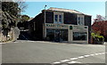
Harry Powell, Clevedon
Kitchens, bedrooms and bathrooms shop on the corner of Hill Road and Park Road.
Image: © Jaggery
Taken: 14 Apr 2014
0.09 miles
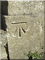
8
Benchmark on Hill Road
An old mark on a gatepost in an older part of Clevedon. See https://www.bench-marks.org.uk/bm45728 for the entry in the Benchmark Database, or Image] for a wider location view.
Image: © Neil Owen
Taken: 31 Aug 2020
0.10 miles
9
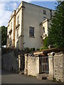
The older buildings along Hill Road
Some fine houses along the lofty reaches of Hill Road, with a benchmark to accompany the architecture on the gatepost - see Image
Image: © Neil Owen
Taken: 31 Aug 2020
0.10 miles
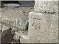
10
Ordnance Survey Cut Mark
This OS cut mark can be found on the gatepost of No17 Hill Road. Woodspring House. It marks a point 42.827m above mean sea level.
Image: © Adrian Dust
Taken: 14 Mar 2016
0.10 miles