IMAGES TAKEN NEAR TO
Kings Road, CLEVEDON, BS21 7HA
Introduction
This page details the photographs taken nearby to Kings Road, BS21 7HA by members of the Geograph project.
The Geograph project started in 2005 with the aim of publishing, organising and preserving representative images for every square kilometre of Great Britain, Ireland and the Isle of Man.

There are currently over 7.5m images from over14,400 individuals and you can help contribute to the project by visiting https://www.geograph.org.uk
Image Map (Loading...)


Getting Data...Please wait
Leaflet Map data © OpenStreetMap
Images are licensed for reuse under creativecommons.org/licenses/by-sa/2.0
Notes
- Clicking on the map will re-center to the selected point.
- The higher the marker number, the further away the image location is from the centre of the postcode.
Image Listing (32 Images Found)
Images are licensed for reuse under creativecommons.org/licenses/by-sa/2.0
Image
Details
Distance
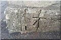
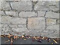
1
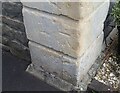
Ordnance Survey Cut Mark
This OS cut mark can be found on the gatepost of No4 Kings Road. It marks a point 60.110m above mean sea level.
Image: © Adrian Dust
Taken: 25 Sep 2021
0.02 miles
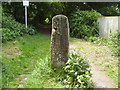
2
Ordnance Survey Cut Mark
This OS cut mark can be found on the gatepost SW side of Old Park Road. It marks a point 69.531m above mean sea level.
Image: © Adrian Dust
Taken: 25 Sep 2021
0.07 miles
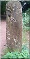
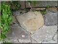
3
An OS Bench Mark
Situated on an old gate post.
One of a number around the Trig point on Dial Hill.
Image: © Anthony Vosper
Taken: 5 Jun 2015
0.07 miles
4
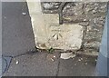
Ordnance Survey Cut Mark
This OS cut mark can be found on the gatepost of No47A Cambridge Road. It marks a point 55.983m above mean sea level.
Image: © Adrian Dust
Taken: 25 Sep 2021
0.07 miles
5
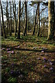
Crocuses on Dial Hill
Crocuses among the trees on Dial Hill, Clevedon.
Image: © Philip Halling
Taken: 13 Mar 2010
0.12 miles
6
Ordnance Survey Cut Mark
This OS cut mark can be found on the wall NE side of Cambridge Road. It marks a point 49.381m above mean sea level.
Image: © Adrian Dust
Taken: 25 Sep 2021
0.12 miles
7
Ordnance Survey Cut Mark
This damaged OS cut mark can be found on the gatepost of No3 The Avenue. It marks a point 174.5ft above mean sea level.
Image: © Adrian Dust
Taken: 25 Sep 2021
0.12 miles
8
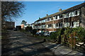
Houses in Walton St Mary
Sixties style housing at Walton St Mary, Clevedon.
Image: © Philip Halling
Taken: 13 Mar 2010
0.12 miles
9
Ordnance Survey Cut Mark
This OS cut mark can be found on the wall of No27 Cambridge Road. It marks a point 61.527m above mean sea level.
Image: © Adrian Dust
Taken: 3 Aug 2022
0.13 miles
10
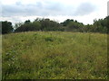
Grassy pillows
The top of Dial Hill has some ancient earthworks. Under the thick grasses are some pillow mounds - usually Mediaeval, they were part of man-made rabbit warrens to supply a controllable source of fresh meat.
Image: © Neil Owen
Taken: 31 Aug 2020
0.14 miles