IMAGES TAKEN NEAR TO
Dial Hill Road, CLEVEDON, BS21 7EW
Introduction
This page details the photographs taken nearby to Dial Hill Road, BS21 7EW by members of the Geograph project.
The Geograph project started in 2005 with the aim of publishing, organising and preserving representative images for every square kilometre of Great Britain, Ireland and the Isle of Man.

There are currently over 7.5m images from over14,400 individuals and you can help contribute to the project by visiting https://www.geograph.org.uk
Image Map
Images are licensed for reuse under creativecommons.org/licenses/by-sa/2.0
Notes
- Clicking on the map will re-center to the selected point.
- The higher the marker number, the further away the image location is from the centre of the postcode.
Image Listing (191 Images Found)
Images are licensed for reuse under creativecommons.org/licenses/by-sa/2.0
Image
Details
Distance
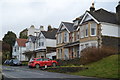
1
Benchmark on Dial Hill Road
A modern mark on a modern (post-war) part of suburban Clevedon. See https://www.bench-marks.org.uk/bm132926 for the entry in the Benchmark Database and Image] for a wider view.
Image: © Neil Owen
Taken: 31 Aug 2020
0.01 miles
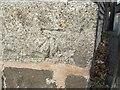
2
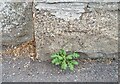
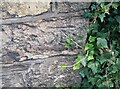
Ordnance Survey Cut Mark
This OS cut mark can be found on the wall at the junction of Dial Hill Road & Castle View Road. It marks a point 59.741m above mean sea level.
Image: © Adrian Dust
Taken: 25 Sep 2021
0.01 miles
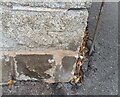
3
Junction of Dial Hill Road and Castle View Road
A quiet suburban part of Clevedon. On the nearest pillar is a benchmark - see Image
Image: © Neil Owen
Taken: 31 Aug 2020
0.02 miles
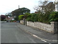
4
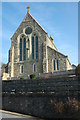
Franciscan Friary in Clevedon
The Franciscan Friary and Parish Church of the Immaculate Conception is situated on high ground overlooking the Bristol Channel.
Image: © Philip Halling
Taken: 13 Mar 2010
0.05 miles
5
Ordnance Survey Cut Mark
This OS cut mark can be found at junction of Dial Hill Road & Durbin Park Road. It marks a point 48.692m above mean sea level.
Image: © Adrian Dust
Taken: 25 Sep 2021
0.07 miles
6
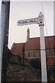
Direction Sign ? Signpost
Located at the junction of Wellington Terrace and the Gardano Round footpath, beside the church of the Immaculate Conception in Clevedon parish. 1 arm and stud finial.
Milestone Society National ID: SO_ST4072
Image: © W Marsh
Taken: Unknown
0.08 miles
7
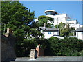
Modernist House above Hill Road, Clevedon
It has been suggested that this house was originally built as a retirement home by the Mekon, when he gave up battling Dan Dare.
Image: © C P Smith
Taken: 25 Jun 2010
0.08 miles
8
Ordnance Survey Cut Mark
This OS cut mark can be found on the wall of the Stancliffe Flats SE side of Wellington Terrace. It marks a point 39.533m above mean sea level.
Image: © Adrian Dust
Taken: 25 Sep 2021
0.08 miles
9
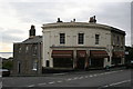
Corner of Copse Road and Marine Hill, Clevedon
The former chemist's established in 1837, The Cellar Lounge was incorporated in 2007 and is 36 Hill Road, the shop front being a unique survival in Clevedon. Along with 36, on the left 51 Copse Road and 51a Christiana form a group of early 19th century Grade II Listed buildings. Adjoining on the right and also Grade II Listed are later, probably mid 19th century, 1 Marine Hill and 36 Hill Road.
Image: © Jo and Steve Turner
Taken: 15 Oct 2010
0.09 miles