IMAGES TAKEN NEAR TO
Wayside Drive, CLEVEDON, BS21 7DU
Introduction
This page details the photographs taken nearby to Wayside Drive, BS21 7DU by members of the Geograph project.
The Geograph project started in 2005 with the aim of publishing, organising and preserving representative images for every square kilometre of Great Britain, Ireland and the Isle of Man.

There are currently over 7.5m images from over14,400 individuals and you can help contribute to the project by visiting https://www.geograph.org.uk
Image Map
Images are licensed for reuse under creativecommons.org/licenses/by-sa/2.0
Notes
- Clicking on the map will re-center to the selected point.
- The higher the marker number, the further away the image location is from the centre of the postcode.
Image Listing (9 Images Found)
Images are licensed for reuse under creativecommons.org/licenses/by-sa/2.0
Image
Details
Distance
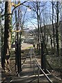
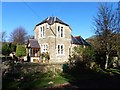
3
To Bennett's Ripple
The footpath on Edward Road South leads down Bennett's Ripple to the school.
Image: © Neil Owen
Taken: 31 Aug 2020
0.13 miles
4
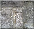
Ordnance Survey Cut Mark
This OS cut mark can be found on the wall of No16 Edward Road. It marks a point 58.982m above mean sea level.
Image: © Adrian Dust
Taken: 25 Sep 2021
0.14 miles
7
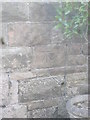
Ordnance Survey Cut Mark
This OS cut mark can be found on No57 The Avenue. It marks a point 12.302m above mean sea level.
Image: © Adrian Dust
Taken: 14 Mar 2016
0.18 miles
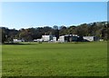
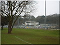
8
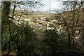
Swiss Valley, East Gordano
View of the Swiss Valley in East Gordano from Strawberry Hill.
Image: © Philip Halling
Taken: 13 Mar 2010
0.20 miles
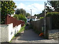
9
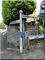
Direction Sign – Signpost on Walton Road, Clevedon
Located on the northeast side of the junction of the B3124 Walton Road and Nortons Wood Lane. Clevedon parish. 2 arms and pyramid finial.
Milestone Society National ID: SO_ST4172
Image: © Roadside Relics
Taken: 7 Jun 2023
0.24 miles