IMAGES TAKEN NEAR TO
Ladye Bay, CLEVEDON, BS21 7BU
Introduction
This page details the photographs taken nearby to Ladye Bay, BS21 7BU by members of the Geograph project.
The Geograph project started in 2005 with the aim of publishing, organising and preserving representative images for every square kilometre of Great Britain, Ireland and the Isle of Man.

There are currently over 7.5m images from over14,400 individuals and you can help contribute to the project by visiting https://www.geograph.org.uk
Image Map (Loading...)


Getting Data...Please wait
Leaflet Map data © OpenStreetMap
Images are licensed for reuse under creativecommons.org/licenses/by-sa/2.0
Notes
- Clicking on the map will re-center to the selected point.
- The higher the marker number, the further away the image location is from the centre of the postcode.
Image Listing (25 Images Found)
Images are licensed for reuse under creativecommons.org/licenses/by-sa/2.0
Image
Details
Distance
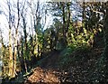
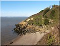
2
Coastal Path
The coastal path above Ladye Point heading north east out of Clevedon.
Image: © Dr Duncan Pepper
Taken: 3 Mar 2008
0.06 miles
3
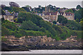
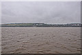
Clevedon : Coastal Scenery
Looking along the coastline of Clevedon.
Image: © Lewis Clarke
Taken: 24 Jul 2015
0.07 miles
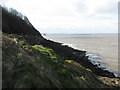
4
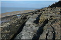
Rocks at Ladye Point
Low tide at Ladye Point.
Image: © Philip Halling
Taken: 13 Mar 2010
0.07 miles
5
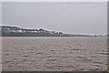
North Somerset : The Bristol Channel
Looking along the Bristol Channel and towards Clevedon.
Image: © Lewis Clarke
Taken: 24 Jul 2015
0.08 miles
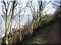
6
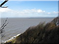
Severn Estuary
Windswept trees on a steep rocky windward shore with fine views north over the Severn estuary with Wales in the distance, taken from the coastal path between Ladye Point and Blackhill Sands north of Clevedon.
Image: © Dr Duncan Pepper
Taken: 3 Mar 2008
0.09 miles
7
North Somerset : Coastal Scenery
Looking towards the coastline of North Somerset from the Bristol Channel.
Image: © Lewis Clarke
Taken: 24 Jul 2015
0.09 miles
8
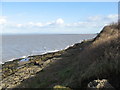
Margaret's Bay
The shoreline adjacent to the coastal path here makes a sudden transition from a steep inaccessible rocky shore to flat rocks, popular with fishermen, and giving fine views over the Margaret's Bay to the Severn bridge and Monmouthshire.
Image: © Dr Duncan Pepper
Taken: 3 Mar 2008
0.09 miles
10
Ladye Point
Rugged coastline viewed from the coastal path north of Clevedon, with the pier and Black Rocks just visible in the distance.
Image: © Dr Duncan Pepper
Taken: 3 Mar 2008
0.10 miles