IMAGES TAKEN NEAR TO
Stone-Edge Batch, CLEVEDON, BS21 6SF
Introduction
This page details the photographs taken nearby to Stone-Edge Batch, BS21 6SF by members of the Geograph project.
The Geograph project started in 2005 with the aim of publishing, organising and preserving representative images for every square kilometre of Great Britain, Ireland and the Isle of Man.

There are currently over 7.5m images from over14,400 individuals and you can help contribute to the project by visiting https://www.geograph.org.uk
Image Map
Images are licensed for reuse under creativecommons.org/licenses/by-sa/2.0
Notes
- Clicking on the map will re-center to the selected point.
- The higher the marker number, the further away the image location is from the centre of the postcode.
Image Listing (11 Images Found)
Images are licensed for reuse under creativecommons.org/licenses/by-sa/2.0
Image
Details
Distance
1
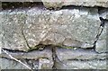
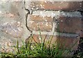
Ordnance Survey Cut Mark
This damaged OS cut mark can be found on the wall SW side of Clevedon Road. It marks a point 29.691m above mean sea level.
Image: © Adrian Dust
Taken: 2 Nov 2021
0.08 miles
2
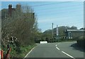
Bend under power lines
This bend in the B3130 at Stone-edge Batch passes under two sets of parallel power lines.
Image: © Ruth Riddle
Taken: 23 Mar 2012
0.08 miles
3
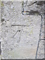
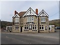
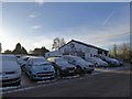
Ordnance Survey Cut Mark
This OS cut mark can be found on the front of the Star Inn. It marks a point 20.547m above mean sea level.
Image: © Adrian Dust
Taken: 6 Mar 2016
0.10 miles
5
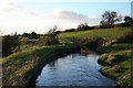
Tickenham: the Land Yeo
The embanked man-made course of the river can clearly be seen here. It does not run in the valley floor. Before Tickenham church – seen on the skyline – the river dog-legs to the right and then to the left, keeping to its contour to reach Tickenham Mill, at one time belonging to the canons of St Augustine's Abbey, Bristol, and thus probably a medieval site
Image: © Martin Bodman
Taken: 8 Dec 2006
0.12 miles
7
Ordnance Survey Cut Mark
This OS cut mark can be found on the wall of Rose Cottage, north side of Clevedon Road. It marks a point 17.547m above mean sea level.
Image: © Adrian Dust
Taken: 2 Nov 2021
0.19 miles
9
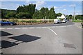
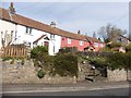
Road junction at Stone-edge-Batch
Road junction on the B3130 at Stone-edge-Batch
Image: © Philip Halling
Taken: 17 Jul 2014
0.20 miles