IMAGES TAKEN NEAR TO
Washingpound Lane, CLEVEDON, BS21 6SA
Introduction
This page details the photographs taken nearby to Washingpound Lane, BS21 6SA by members of the Geograph project.
The Geograph project started in 2005 with the aim of publishing, organising and preserving representative images for every square kilometre of Great Britain, Ireland and the Isle of Man.

There are currently over 7.5m images from over14,400 individuals and you can help contribute to the project by visiting https://www.geograph.org.uk
Image Map (Loading...)


Getting Data...Please wait
Leaflet Map data © OpenStreetMap
Images are licensed for reuse under creativecommons.org/licenses/by-sa/2.0
Notes
- Clicking on the map will re-center to the selected point.
- The higher the marker number, the further away the image location is from the centre of the postcode.
Image Listing (56 Images Found)
Images are licensed for reuse under creativecommons.org/licenses/by-sa/2.0
Image
Details
Distance
1
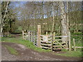
The path off Washing Pound Lane
A short trip across a grassy (and muddy!) field to reach the Clevedon Road or the Middle Yeo.
Image: © Neil Owen
Taken: 5 Apr 2018
0.02 miles
2
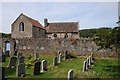
Tickenham Court
Tickenham Court viewed from the churchyard of Tickenham church.
Image: © Philip Halling
Taken: 17 Jul 2014
0.03 miles
3
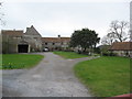
Tickenham Court
Tickenham Court looking NW, this building, now a farm has a great hall dating from the 14th century.
Image: © Dr Duncan Pepper
Taken: 23 Feb 2008
0.04 miles
4
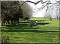
A new season every day
It's early April and the warm sunshine is making the wooly sheep take to the shadows already. Was it only a month ago that we were knee-high in snow?
Image: © Neil Owen
Taken: 5 Apr 2018
0.04 miles
5
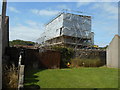
All wrapped up
Tickenham Court surrounded by scaffolding and polythene whilst restoration work takes place.
Image: © Anthony Vosper
Taken: 13 Jul 2019
0.04 miles
6
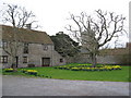
Tickenham Court
Looking SW at Tickenham Court with the church tower of St Quiricus & St Juliet in the background. The buildings are now a farm but parts date from the 14th century.
Image: © Dr Duncan Pepper
Taken: 23 Feb 2008
0.04 miles
7
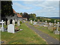
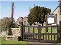
A walk through the churchyard
The church of St Quiricus and St Julietta at Ticnenham.
Image: © Anthony Vosper
Taken: 13 Jul 2019
0.05 miles
8
From the days before cars
A mounting block at the edge of the churchyard.
It would be difficult to use today as there is a raised flower bed behind the wall.
Image: © Anthony Vosper
Taken: 13 Jul 2019
0.05 miles
9
A stone stile for St Quiricus and St Julietta
The entrance to the little church offers some alternative to the usual gate. The church is dated to at least the eleventh century due to its Norman stonework, but could well be Saxon in origin.
The dedication is a rather unusual one: widow Julietta and her young son Quiricus (other variations of the name are evident) were travelling in Tarsus in 304AD, when they were arrested for being Christians. Julietta was tortured to force her to deny her faith but held out. Her son scratched the face of the Governor Alexander and was thrown down the stone steps, killing him. Julietta thanked God for her son's martyrdom, but the enraged Alexander then beheaded her.
Image: © Neil Owen
Taken: 5 Apr 2018
0.05 miles
10
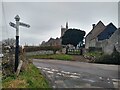
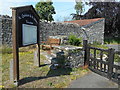
Church of Sts Quiricus and Julietta, Tickenham
Church of Saints Quiricus and Julietta in Tickenham.
Somerset County Council signpost at the left.
Photograph taken from the junction of Church Lane and Washing Pound Lane.
Image: © Kevin Pearson
Taken: 16 Feb 2021
0.05 miles