IMAGES TAKEN NEAR TO
Fearnville Estate, CLEVEDON, BS21 6PX
Introduction
This page details the photographs taken nearby to Fearnville Estate, BS21 6PX by members of the Geograph project.
The Geograph project started in 2005 with the aim of publishing, organising and preserving representative images for every square kilometre of Great Britain, Ireland and the Isle of Man.

There are currently over 7.5m images from over14,400 individuals and you can help contribute to the project by visiting https://www.geograph.org.uk
Image Map
Images are licensed for reuse under creativecommons.org/licenses/by-sa/2.0
Notes
- Clicking on the map will re-center to the selected point.
- The higher the marker number, the further away the image location is from the centre of the postcode.
Image Listing (84 Images Found)
Images are licensed for reuse under creativecommons.org/licenses/by-sa/2.0
Image
Details
Distance
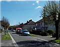
1
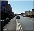
Strode Road, Clevedon
A sign on the corner of Old Church Road warns of a weak bridge 350 yards ahead on Strode Road.
Image: © Jaggery
Taken: 14 Apr 2014
0.06 miles
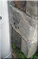
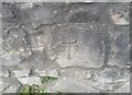
2
Ordnance Survey Cut Mark
This OS cut mark can be found on No13 Strode Road. It marks a point 6.859m above mean sea level.
Image: © Adrian Dust
Taken: 25 Sep 2021
0.06 miles
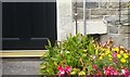
3
Ordnance Survey Cut Mark
This OS cut mark can be found on the wall dividing Nos 82 & 84 Old Church Road. It marks a point 6.864m above mean sea level.
Image: © Adrian Dust
Taken: 25 Sep 2021
0.07 miles
4
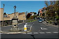
Victoria Road, Clevedon
Viewed across Old Church Road. A lamp is on top of a triangular stone structure that could be a disused drinking fountain.
Image: © Jaggery
Taken: 14 Apr 2014
0.11 miles
5
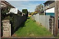
Path by Coleridge Vale Road South
The only access to a small green space entirely surrounded by housing.
Image: © Derek Harper
Taken: 22 Sep 2017
0.11 miles
6
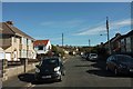
Coleridge Vale Road South, Clevedon
From beside the path shown in Image The church is the grade II* listed Christ Church https://www.historicengland.org.uk/listing/the-list/list-entry/1129663 Image
Image: © Derek Harper
Taken: 22 Sep 2017
0.11 miles
7
Beach Avenue, Clevedon
Viewed from the Old Church Road end.
Image: © Jaggery
Taken: 14 Apr 2014
0.12 miles
8
Ordnance Survey Cut Mark
This OS cut mark can be found on the wall north side of Old Church Road. It marks a point 7.102m above mean sea level.
Image: © Adrian Dust
Taken: 25 Sep 2021
0.12 miles
9
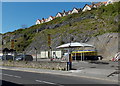
Cliffside car wash in Clevedon
Magic D&L Hand Car Wash viewed across Old Church Road.
Image: © Jaggery
Taken: 14 Apr 2014
0.13 miles
10
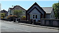
Christadelphian Church, Clevedon
Viewed across Coleridge Vale Road North, near the Old Church Road junction. The Christadelphians (Brothers or Sisters in Christ) are a worldwide community established in the mid 19th century. Christadelphians base their beliefs entirely on the Bible, the inspired Word of God, and aim to read it every day. By following a plan they read the whole of the Old Testament once in a year and the New Testament twice.
Image: © Jaggery
Taken: 14 Apr 2014
0.13 miles