IMAGES TAKEN NEAR TO
Coleridge Vale Road East, CLEVEDON, BS21 6NS
Introduction
This page details the photographs taken nearby to Coleridge Vale Road East, BS21 6NS by members of the Geograph project.
The Geograph project started in 2005 with the aim of publishing, organising and preserving representative images for every square kilometre of Great Britain, Ireland and the Isle of Man.

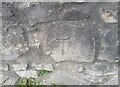
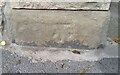
There are currently over 7.5m images from over14,400 individuals and you can help contribute to the project by visiting https://www.geograph.org.uk
Image Map
Images are licensed for reuse under creativecommons.org/licenses/by-sa/2.0
Notes
- Clicking on the map will re-center to the selected point.
- The higher the marker number, the further away the image location is from the centre of the postcode.
Image Listing (155 Images Found)
Images are licensed for reuse under creativecommons.org/licenses/by-sa/2.0
Image
Details
Distance
1
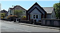
Christadelphian Church, Clevedon
Viewed across Coleridge Vale Road North, near the Old Church Road junction. The Christadelphians (Brothers or Sisters in Christ) are a worldwide community established in the mid 19th century. Christadelphians base their beliefs entirely on the Bible, the inspired Word of God, and aim to read it every day. By following a plan they read the whole of the Old Testament once in a year and the New Testament twice.
Image: © Jaggery
Taken: 14 Apr 2014
0.05 miles
2
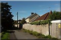
Path, Clevedon
Footpath LA22 23/20 links Great Western Road to Kingsley Road.
Image: © Derek Harper
Taken: 22 Sep 2017
0.06 miles
3
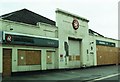
Disused Art Deco Garage, Old Church Road
Situated next to the rebuild Art Deco Curzon Community Cinema this garage is in the Art Moderne style, more later streamlined form of Art Deco.
Image: © Alan Cooper
Taken: 17 Sep 2005
0.06 miles
4
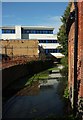
Land Yeo at Clevedon
The Land Yeo used to power numerous mills along its course, at least two of them in Clevedon https://en.wikipedia.org/wiki/Land_Yeo#Mills . Waverley House, in the background, was formerly offices but now has consent to be used residentially https://www.n-somerset.gov.uk/wp-content/uploads/2017/07/Waverley-House-Clevedon.pdf . The brick wall on the right is at the rear of the Curzon Cinema.
Image: © Derek Harper
Taken: 22 Sep 2017
0.07 miles
5
Ordnance Survey Cut Mark
This OS cut mark can be found on the wall north side of Old Church Road. It marks a point 7.102m above mean sea level.
Image: © Adrian Dust
Taken: 25 Sep 2021
0.07 miles
6
Ordnance Survey Cut Mark
This OS cut mark can be found on the wall of No43 Old Church Road. It marks a point 5.965m above mean sea level.
Image: © Adrian Dust
Taken: 25 Sep 2021
0.07 miles
7
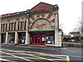
Curzon Community Cinema, Clevedon
The community run Curzon Cinema in Clevedon is one of the oldest continually operating purpose-built cinemas in the world. It opened in April 1920 with the first show being to raise funds for the survivors and relatives of those lost on the Titanic.
Image: © Steve Barnes
Taken: 3 Apr 2015
0.07 miles
8
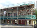
The Curzon under the netting
The Curzon is a locally owned community asset and consequently doesn't have the financial support of the multi-national cinema chains. When funding permits, the old building needs plenty of costly maintenance.
Image: © Neil Owen
Taken: 31 Aug 2020
0.07 miles
9
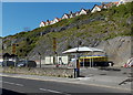
Cliffside car wash in Clevedon
Magic D&L Hand Car Wash viewed across Old Church Road.
Image: © Jaggery
Taken: 14 Apr 2014
0.08 miles
10
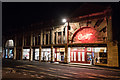
Clevedon Curzon Cinema at night
The cinema has been in continuous operation since April 1912 and was saved by the local community in 1996. We add to the Curzon story every day with our vibrant programme of film and events. https://www.curzon.org.uk/
Image: © Ian Knox
Taken: 17 Nov 2017
0.08 miles