IMAGES TAKEN NEAR TO
Kenn Road, CLEVEDON, BS21 6LH
Introduction
This page details the photographs taken nearby to Kenn Road, BS21 6LH by members of the Geograph project.
The Geograph project started in 2005 with the aim of publishing, organising and preserving representative images for every square kilometre of Great Britain, Ireland and the Isle of Man.

There are currently over 7.5m images from over14,400 individuals and you can help contribute to the project by visiting https://www.geograph.org.uk
Image Map
Images are licensed for reuse under creativecommons.org/licenses/by-sa/2.0
Notes
- Clicking on the map will re-center to the selected point.
- The higher the marker number, the further away the image location is from the centre of the postcode.
Image Listing (26 Images Found)
Images are licensed for reuse under creativecommons.org/licenses/by-sa/2.0
Image
Details
Distance
1
Kenn Road Methodist Church, Clevedon
In February 1949, Kenn Road Methodist Hall was officially opened on this site,
housed in two disused Nissen huts. The building seen here dates from 1990.
Image: © Jaggery
Taken: 14 Apr 2014
0.03 miles
2
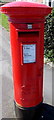
King Edward VIII postbox in Clevedon
This postbox on the corner of Kenn Road and St Michael's Road http://www.geograph.org.uk/photo/3930848 is a rarity.
The insignia dates it to the 326 day reign of King Edward VIII who became
king on the death of his father on January 20th 1936 and abdicated on December 11th 1936.
One source states that some Edward VIII postbox doors were replaced
by George VI doors, a fate which did not happen here.
Image: © Jaggery
Taken: 14 Apr 2014
0.03 miles
3
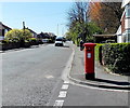
King Edward VIII postbox on a suburban corner in Clevedon
On the corner of Kenn Road and St Michael's Road. http://www.geograph.org.uk/photo/3930838 to a closer view and some details of the rarity.
Image: © Jaggery
Taken: 14 Apr 2014
0.03 miles
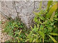
5
Ordnance Survey Cut Mark
This OS cut mark can be found on No157 Kenn Road. It marks a point 6.410m above mean sea level.
Image: © Adrian Dust
Taken: 3 Aug 2022
0.05 miles
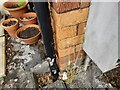
6
Ordnance Survey Cut Mark
This OS cut mark can be found on Penny Cottage. It marks a point 6.680m above mean sea level.
Image: © Adrian Dust
Taken: 3 Aug 2022
0.08 miles
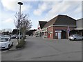
8
Clevedon : Tesco Petrol Station
The filling station at the Tesco store in Clevedon.
Image: © Lewis Clarke
Taken: 24 Jul 2015
0.12 miles
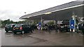
9
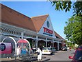
Tesco, Clevedon
A closer look at the store shown in Image, with the distinctive (?) tiling, and a bit of a struggle with a trolley.
Image: © Derek Harper
Taken: 3 Jun 2006
0.12 miles
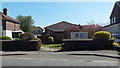
10
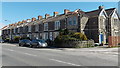
Kenn Road houses, Clevedon
The row of houses on the east side of the B3133 Kenn Road
ends at the corner of Kennaway Road, about 55 metres ahead.
Image: © Jaggery
Taken: 14 Apr 2014
0.12 miles