IMAGES TAKEN NEAR TO
Valley Road, CLEVEDON, BS21 6AQ
Introduction
This page details the photographs taken nearby to Valley Road, BS21 6AQ by members of the Geograph project.
The Geograph project started in 2005 with the aim of publishing, organising and preserving representative images for every square kilometre of Great Britain, Ireland and the Isle of Man.

There are currently over 7.5m images from over14,400 individuals and you can help contribute to the project by visiting https://www.geograph.org.uk
Image Map
Images are licensed for reuse under creativecommons.org/licenses/by-sa/2.0
Notes
- Clicking on the map will re-center to the selected point.
- The higher the marker number, the further away the image location is from the centre of the postcode.
Image Listing (57 Images Found)
Images are licensed for reuse under creativecommons.org/licenses/by-sa/2.0
Image
Details
Distance
1
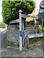
Direction Sign – Signpost on Walton Road, Clevedon
Located on the northeast side of the junction of the B3124 Walton Road and Nortons Wood Lane. Clevedon parish. 2 arms and pyramid finial.
Milestone Society National ID: SO_ST4172
Image: © Roadside Relics
Taken: 7 Jun 2023
0.08 miles
2
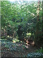
Steep on Strawberry Hill
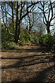
The woodland of Strawberry Hill lies along the slopes of Swiss Valley.
Image: © Neil Owen
Taken: 31 Aug 2020
0.09 miles
3
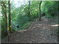
Dropping down or staying high
The footpath through Strawberry Hill forks here.
Image: © Neil Owen
Taken: 31 Aug 2020
0.10 miles
4
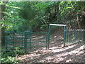
The path through Strawberry Hill
With some sturdy fencing and a height restriction. Just what sort of tall visitor would be excluded?
Image: © Neil Owen
Taken: 31 Aug 2020
0.10 miles
5
Ordnance Survey Rivet
This OS rivet can be found on a rock SW side of the track on Strawberry Hill. It marks a point 55.471m above mean sea level.
Image: © Adrian Dust
Taken: 3 Aug 2022
0.10 miles
6
Woodland footpath, East Clevedon
The route of the Gordano Round through woodland above East Clevedon.
Image: © Philip Halling
Taken: 13 Mar 2010
0.11 miles
7
Grasping roots
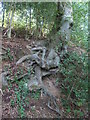
The valley of Strawberry Hill is steep and the trees have to make strenuous efforts to stay in the ground.
Image: © Neil Owen
Taken: 31 Aug 2020
0.12 miles
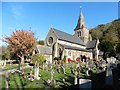
10
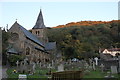
All Saints Church, All Saints Lane, Clevedon
Grade II Listed church of 1861 by C E Giles. The church was built for Rhoda, Lady Elton, paid for from her private estate. Her husband, Sir Arthur Hallam Elton of Clevedon Court, gave the land, built the vicarage and endowed the benefice. Originally an aisled nave with transepts buttressing a spired tower it was extended, mostly by the Elton family, over the years. Lady Chapel added 1901. Between 1910 and 1913 the choir vestry, Chapel of the Holy Name and baptistery were added. An entrance porch was added in 1922 as a memorial to churchwarden Silas Dyer. The organ was built by Henry Willis in 1877 and rebuilt by Percy Daniels and Company in 1949 and again more recently. The interior is largely to the designs of Sir Ninian Comper.
Image: © Jo and Steve Turner
Taken: 31 Oct 2015
0.13 miles