IMAGES TAKEN NEAR TO
Cannons Gate, CLEVEDON, BS21 5HW
Introduction
This page details the photographs taken nearby to Cannons Gate, BS21 5HW by members of the Geograph project.
The Geograph project started in 2005 with the aim of publishing, organising and preserving representative images for every square kilometre of Great Britain, Ireland and the Isle of Man.

There are currently over 7.5m images from over14,400 individuals and you can help contribute to the project by visiting https://www.geograph.org.uk
Image Map
Images are licensed for reuse under creativecommons.org/licenses/by-sa/2.0
Notes
- Clicking on the map will re-center to the selected point.
- The higher the marker number, the further away the image location is from the centre of the postcode.
Image Listing (30 Images Found)
Images are licensed for reuse under creativecommons.org/licenses/by-sa/2.0
Image
Details
Distance
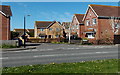
1
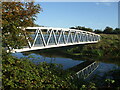
Colehouse footbridge
A modern geometric footbridge crosses the river. In years gone by the Blind Yeo was further south and a lot smaller, but was also crossed by a footbridge.
Image: © Neil Owen
Taken: 27 Sep 2020
0.10 miles
2
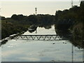
A bridge reflection
The light has somewhat obscured the footbridge over the Blind Yeo. The latter is a modern recreation of the old river, which was a lot narrower and a little to the south before excavation in 1952-3. Before then, the old railway to Clevedon station would have run between them, and the footbridge respects the old footpath of many years standing.
Image: © Neil Owen
Taken: 27 Sep 2020
0.11 miles
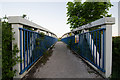
3
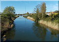
Blind Yeo footbridge, Clevedon
Viewed from the bridge carrying the B3133 over the river. The footbridge is about 120 metres away.
Image: © Jaggery
Taken: 14 Apr 2014
0.11 miles
4
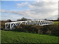
Bridge across the Blind Yeo
A footpath goes across this attractive bridge and leads south away from Clevedon into the low-lying, heavily drained fields to the east of the Severn Estuary.
Image: © Sharon Loxton
Taken: 27 Jan 2008
0.12 miles
5
River Mead, Clevedon
Houses on the north bank of Blind Yeo, http://www.geograph.org.uk/photo/4147416 viewed across the B3133.
Image: © Jaggery
Taken: 14 Apr 2014
0.14 miles
6
Footbridge across the Blind Yeo
The footbridge across the Blind Yeo leading to Coalhouse Lane
Image: © Ian Knox
Taken: 22 May 2013
0.14 miles
7
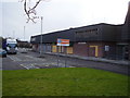
Even Supermarkets can close
The former Millcross Kwik Save is boarded up awaiting redevelopment.
Image: © Anthony Vosper
Taken: 16 Feb 2010
0.15 miles
8
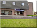
Standing defiant
Whilst the rest of the former Millcross Kwik Save site is boarded up awaiting redevelopment the Chippy remains open.
Image: © Anthony Vosper
Taken: 16 Feb 2010
0.16 miles
9
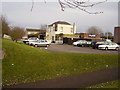
The Crabtree, Millcross
Just off Southern Way serving the local estate.
Image: © Anthony Vosper
Taken: 16 Feb 2010
0.17 miles
10

Kenn Road looking past the junction with River Mead
The view southbound on the B3133.
Image: © Ruth Riddle
Taken: 10 Jul 2012
0.18 miles