IMAGES TAKEN NEAR TO
Yeoward Road, CLEVEDON, BS21 5AT
Introduction
This page details the photographs taken nearby to Yeoward Road, BS21 5AT by members of the Geograph project.
The Geograph project started in 2005 with the aim of publishing, organising and preserving representative images for every square kilometre of Great Britain, Ireland and the Isle of Man.

There are currently over 7.5m images from over14,400 individuals and you can help contribute to the project by visiting https://www.geograph.org.uk
Image Map (Loading...)


Getting Data...Please wait
Leaflet Map data © OpenStreetMap
Images are licensed for reuse under creativecommons.org/licenses/by-sa/2.0
Notes
- Clicking on the map will re-center to the selected point.
- The higher the marker number, the further away the image location is from the centre of the postcode.
Image Listing (11 Images Found)
Images are licensed for reuse under creativecommons.org/licenses/by-sa/2.0
Image
Details
Distance
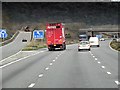
4
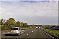
Clevedon : Junction 20 Clevedon Interchange
The sliproad off the M5 Motorway.
Image: © Lewis Clarke
Taken: 22 Sep 2019
0.20 miles
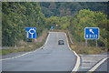
9
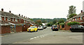
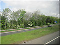
Yeomoor, Clevedon
A junction on a cul-de-sac off the B3133 Moor Lane. In the background is Fir Wood.
Image: © Derek Harper
Taken: 18 Sep 2021
0.23 miles
10
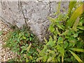
Ordnance Survey Cut Mark
This OS cut mark can be found on Penny Cottage. It marks a point 6.680m above mean sea level.
Image: © Adrian Dust
Taken: 3 Aug 2022
0.23 miles