IMAGES TAKEN NEAR TO
Glass Wharf, BRISTOL, BS2 0ZX
Introduction
This page details the photographs taken nearby to Glass Wharf, BS2 0ZX by members of the Geograph project.
The Geograph project started in 2005 with the aim of publishing, organising and preserving representative images for every square kilometre of Great Britain, Ireland and the Isle of Man.

There are currently over 7.5m images from over14,400 individuals and you can help contribute to the project by visiting https://www.geograph.org.uk
Image Map
Images are licensed for reuse under creativecommons.org/licenses/by-sa/2.0
Notes
- Clicking on the map will re-center to the selected point.
- The higher the marker number, the further away the image location is from the centre of the postcode.
Image Listing (795 Images Found)
Images are licensed for reuse under creativecommons.org/licenses/by-sa/2.0
Image
Details
Distance
1
Avon Street
Runs parallel to the Floating Harbour.
Image: © Thomas Nugent
Taken: 7 Sep 2010
0.01 miles
2
Walkway at Burges Salmon
On the north bank of the Floating Harbour at Temple Footbridge.
Image: © Thomas Nugent
Taken: 7 Sep 2010
0.01 miles
3
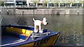
Gromit on the ferry Brigantia, Temple Meads Station Landing
The famous and much-loved Gromit has been the figurehead of the Bristol Ferry Boat, Brigantia since 2013. The ferry is the most convenient way to travel from the SS Great Britain to Temple Meads railway station https://www.bristolferry.com/our-boats/brigantia/
Image: © Brian Robert Marshall
Taken: 2 May 2018
0.01 miles
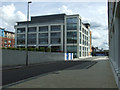
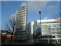
4
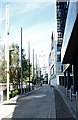
1 Glass Wharf, Bristol
On the right are the offices of legal firm Burges Salmon LLP.
Image: © Derek Harper
Taken: 5 Apr 2018
0.02 miles
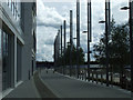
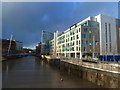
5
Glass Wharf, Bristol
On the left is One Glass Wharf https://stridetreglown.com/projects/one-glass-wharf-bristol/ .
Image: © Derek Harper
Taken: 5 Apr 2018
0.02 miles
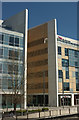
6
Burges Salmon building
Viewed from Temple Back East on the opposite bank of the Floating Harbour.
Image: © Thomas Nugent
Taken: 7 Sep 2010
0.02 miles
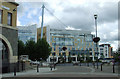
7
Offices across the River Avon Navigation from Temple Meads Station, Bristol
Image: © Ruth Sharville
Taken: 14 Jan 2011
0.02 miles
8
River Avon Navigation, offices and new footbridge, Temple Quay, Bristol
Photo taken from an even newer footbridge - photo Image
It shows the navigable section of the Bristol Avon.
http://www.information-britain.co.uk/naturaldetail.php?id=33
Image: © Ruth Sharville
Taken: 14 Jan 2011
0.02 miles
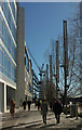
9
Temple Meads Quay Vicinity, Bristol 2
A view along Glass Wharf - at the side of the Floating Harbour - looking in the direction of the ultra modern, stainless steel, S-shaped Valentine bridge, and beyond that, Temple Bridge. 2-3 minutes walk away behind the photographer lies another ultra modern stainless bridge linking Temple Meads Quay and the west side of Temple Meads Railway Station.
Image: © David Hallam-Jones
Taken: 13 Aug 2017
0.03 miles
10
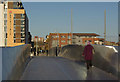
Footbridge over the Floating Harbour
A lady crosses by means of the new footbridge from Temple Meads station into The Dings - an area that has had much effort put into regeneration in recent years.
Image: © Stephen McKay
Taken: 10 Nov 2010
0.03 miles