IMAGES TAKEN NEAR TO
Victoria Road, BRISTOL, BS2 0UJ
Introduction
This page details the photographs taken nearby to Victoria Road, BS2 0UJ by members of the Geograph project.
The Geograph project started in 2005 with the aim of publishing, organising and preserving representative images for every square kilometre of Great Britain, Ireland and the Isle of Man.

There are currently over 7.5m images from over14,400 individuals and you can help contribute to the project by visiting https://www.geograph.org.uk
Image Map (Loading...)


Getting Data...Please wait
Leaflet Map data © OpenStreetMap
Images are licensed for reuse under creativecommons.org/licenses/by-sa/2.0
Notes
- Clicking on the map will re-center to the selected point.
- The higher the marker number, the further away the image location is from the centre of the postcode.
Image Listing (514 Images Found)
Images are licensed for reuse under creativecommons.org/licenses/by-sa/2.0
Image
Details
Distance
1
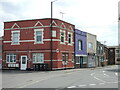
Both Grafton's are lost
The large brick building on the corner was the old Grafton Hotel, facing onto what used to be Grafton Street. That street has been demolished, like many old terraces in this part of town.
Image: © Neil Owen
Taken: 29 Apr 2022
0.01 miles
2
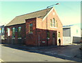
Chauncey's Timber Flooring premises, St Philips, Bristol
On the corner of Chapel Street and Victoria Road. An inscription in stone above the three windows on the Chapel Street (right) side shows JUBILEE ROOM 1887.
Image: © Jaggery
Taken: 11 Nov 2012
0.01 miles
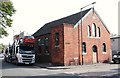
3
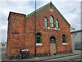
The front of the old Room
This religious building started life in 1887 as the Jubilee Room, with the Salvation Army having a Mission Hall next door (no longer here). It held meetings and services until July, 1942, whereupon it announced it would be removed from the Registry. It appears that a local Methodist church had been hit during the war and the congregation took over at Chapel Street for some time before the building became used for non-religious purposes.
Note the two different vintages of street signs. See Image] for the side elevation.
Image: © Neil Owen
Taken: 29 Apr 2022
0.01 miles
4
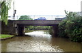
Feeder Canal, Avon Street Bridge
Looking west. Beyond the bridge the canal joins Bristol Floating Harbour.
Image: © Pierre Terre
Taken: 20 May 2006
0.02 miles
5
Albert Road Vicinity, Bristol 2
This former Methodist Mission on the corner of Chapel street was built in 1887. The surrounding area was redeveloped around it, except for some Victorian houses, leading to the disappearance of various scrap yards and a derelict school. The chapel however, continued to function until 2002. Finally, along with a nearby public house it featured in an episode of BBC1's Casualty before becoming derelict. More recently and by virtue of a further extension (or extensions) to it, it has become an industrial unit for a firm of wooden floor manufacturers.
Image: © David Hallam-Jones
Taken: 11 Aug 2017
0.02 miles
6
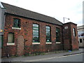
The Jubilee Room on Victoria Road
An old religious hall of 1887 has seen different clientele over the years. See Image] for a look at the front in Chapel Street.
Image: © Neil Owen
Taken: 29 Apr 2022
0.02 miles
7
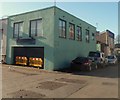
Tops Massage Studio, St. Philips, Bristol
Located at 16 Chapel Street on the corner of Stanhope Street.
Image: © Jaggery
Taken: 11 Nov 2012
0.02 miles
8
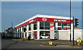
Kia Motors
Located at the junction of Albert Road and Feeder Road in central Bristol.
Image: © Mary and Angus Hogg
Taken: 28 Jun 2018
0.02 miles
9
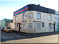
The Old Fox Inn, St Philips, Bristol
On the corner of Chapel Street and Victoria Road, near Feeder Road and Marsh Bridge.
Image: © Jaggery
Taken: 11 Nov 2012
0.03 miles
10
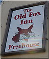
The Old Fox Inn name sign, St Philips, Bristol
The sign is on the corner of this pub. http://www.geograph.org.uk/photo/3223524
Image: © Jaggery
Taken: 11 Nov 2012
0.03 miles