IMAGES TAKEN NEAR TO
Feeder Road, BRISTOL, BS2 0TH
Introduction
This page details the photographs taken nearby to Feeder Road, BS2 0TH by members of the Geograph project.
The Geograph project started in 2005 with the aim of publishing, organising and preserving representative images for every square kilometre of Great Britain, Ireland and the Isle of Man.

There are currently over 7.5m images from over14,400 individuals and you can help contribute to the project by visiting https://www.geograph.org.uk
Image Map (Loading...)


Getting Data...Please wait
Leaflet Map data © OpenStreetMap
Images are licensed for reuse under creativecommons.org/licenses/by-sa/2.0
Notes
- Clicking on the map will re-center to the selected point.
- The higher the marker number, the further away the image location is from the centre of the postcode.
Image Listing (117 Images Found)
Images are licensed for reuse under creativecommons.org/licenses/by-sa/2.0
Image
Details
Distance
1
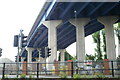
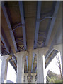
St Philip's Causeway
The flyover crossing the Feeder Canal and Feeder Road, looking SE from the canal.
Image: © Pierre Terre
Taken: 20 May 2006
0.05 miles
2

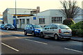
Hills Delivery, Bristol
Hills Delivery is a family-owned transport and delivery business, located at 87 Feeder Road.
Image: © Jaggery
Taken: 8 Nov 2012
0.07 miles
3

Feeder Road
This road as its name suggests runs along side the Feeder , the waterway to the right. The Feeder is an artificial canal cut to give ships access to the upper part of the River Avon from Bristol Floating Harbour. The box bridges carry pipelines over the Feeder Canal
Image: © Nigel Mykura
Taken: 23 Feb 2013
0.08 miles
4
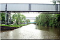
Service Bridges, Feeder Canal
Looking west past the service bridges towards Silverthorn Lane footbridge.
Image: © Pierre Terre
Taken: 20 May 2006
0.08 miles
5
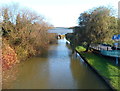
A view eastwards along The Feeder, Bristol
Viewed from this footbridge http://www.geograph.org.uk/photo/3506348 looking away from the city centre along The Feeder which connects the city centre Floating Harbour (near Temple Meads Station) with the River Avon upstream of Netham Weir. On the right are Feeder Road and the footbridge access ramp.
Image: © Jaggery
Taken: 8 Nov 2012
0.09 miles
7
Bristol Rope and Twine
Located at 80 Feeder Road, on the corner of Atlas Street, Bristol.
Bristol Rope & Twine is a UK manufacturer, importer and distributor of natural/synthetic rope and cordage to the commercial, industrial, manufacturing, marine, hardware and leisure industries.
Image: © Jaggery
Taken: 8 Nov 2012
0.09 miles
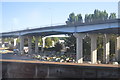
9
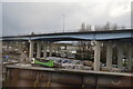
Holding up the traffic
The underside of the recent St Philip's Causeway (A4320), which straddles the Feeder Canal and joins the Avonmeads and Lawrence Hill areas.
Image: © Neil Owen
Taken: 27 Jan 2012
0.09 miles
10
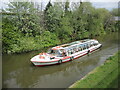
'The Bagheera'
A river cruiser passes along the Feeder canal, with a school party on board.
From the Bristol Packet website:
'Built by Molenaars Shipyard in Zaandam, Holland in 1973, she was built to work as a passenger vessel on Lake Lucerne, Switzerland. Her original name was Hertenstein. She was taken to Antwerp via the European inland waterway system in 1988 and re-named Bagheera (the Black Panther from The Jungle Book) as she carried passengers to a Zoo near Antwerp. Bristol Packet brought Bagheera to Bristol via the Belgium and French canal system and then on a truck to Bristol in 2002.'
Image: © Neil Owen
Taken: 29 Apr 2022
0.10 miles