IMAGES TAKEN NEAR TO
Feeder Road, BRISTOL, BS2 0SB
Introduction
This page details the photographs taken nearby to Feeder Road, BS2 0SB by members of the Geograph project.
The Geograph project started in 2005 with the aim of publishing, organising and preserving representative images for every square kilometre of Great Britain, Ireland and the Isle of Man.

There are currently over 7.5m images from over14,400 individuals and you can help contribute to the project by visiting https://www.geograph.org.uk
Image Map (669 Images)


Getting Data...Please wait
Leaflet Map data © OpenStreetMap
Images are licensed for reuse under creativecommons.org/licenses/by-sa/2.0
Notes
- Clicking on the map will re-center to the selected point.
- The higher the marker number, the further away the image location is from the centre of the postcode.
Image Listing (669 Images Found)
Images are licensed for reuse under creativecommons.org/licenses/by-sa/2.0
Image
Details
Distance
1
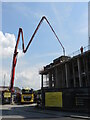
A long feed on Feeder Road
The work to build an apartment block requires the supply of fresh concrete to just where it's needed - a long, spidery arm pumps the mixture from the vehicle to the upper floors.
Image: © Neil Owen
Taken: 8 May 2024
0.01 miles
2
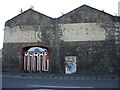
Old oil mill building
This is one of the remaining structures of the former J. Robinson and Company Marsh Mills. The firm was an oil mill and seed storage business, with hay and corn appearing to be kept in this one. In later times, the businesses changed and are now almost all gone. The adjoining area known as the Stone Yard is currently cleared of all its old sites.
Image: © Neil Owen
Taken: 26 Apr 2022
0.02 miles
3
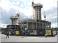
High quality student living
So says the hoardings. Occupants of the new development will have a grand view over the Feeder Canal, Marsh Bridge and the other new blocks also going up opposite.
Image: © Neil Owen
Taken: 15 May 2024
0.02 miles
5
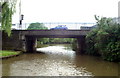
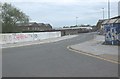
Feeder Canal, Avon Street Bridge
Looking west. Beyond the bridge the canal joins Bristol Floating Harbour.
Image: © Pierre Terre
Taken: 20 May 2006
0.03 miles
6
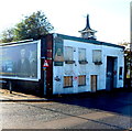
Derelict building, Feeder Road, Bristol
The building on the corner of Feeder Road and Albert Road was formerly the premises
of Chauncey's Timber Flooring Ltd who moved to nearby premises in Victoria Road. http://www.geograph.org.uk/photo/3224464
Image: © Jaggery
Taken: 8 Nov 2012
0.03 miles
7
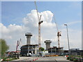
Building clouds?
The Feeder Road development is well in hand, but the cranes seem to be involved with higher things.
Image: © Neil Owen
Taken: 8 May 2024
0.03 miles
8
The old Stone Yard
In the nineteenth century this open ground was home to flax mills, linoleum works, limekilns and (until the early twentieth) fever isolation hospitals. They have gone now and the site looks ready for a completely new set of businesses to move in. Meanwhile, the artists make use of it.
Image: © Neil Owen
Taken: 26 Apr 2022
0.03 miles
9
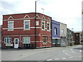
Both Grafton's are lost
The large brick building on the corner was the old Grafton Hotel, facing onto what used to be Grafton Street. That street has been demolished, like many old terraces in this part of town.
Image: © Neil Owen
Taken: 29 Apr 2022
0.03 miles
10
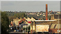
Feeder Road, Marsh Bridge
A view from Bristol Temple Meads Station.
Image: © Derek Harper
Taken: 2 May 2018
0.04 miles