IMAGES TAKEN NEAR TO
Princess Street, BRISTOL, BS2 0RR
Introduction
This page details the photographs taken nearby to Princess Street, BS2 0RR by members of the Geograph project.
The Geograph project started in 2005 with the aim of publishing, organising and preserving representative images for every square kilometre of Great Britain, Ireland and the Isle of Man.

There are currently over 7.5m images from over14,400 individuals and you can help contribute to the project by visiting https://www.geograph.org.uk
Image Map (Loading...)


Getting Data...Please wait
Leaflet Map data © OpenStreetMap
Images are licensed for reuse under creativecommons.org/licenses/by-sa/2.0
Notes
- Clicking on the map will re-center to the selected point.
- The higher the marker number, the further away the image location is from the centre of the postcode.
Image Listing (146 Images Found)
Images are licensed for reuse under creativecommons.org/licenses/by-sa/2.0
Image
Details
Distance
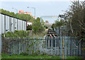
1
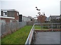
The Bristol and Bath Railway path diverts here
Up onto Princess Street to avoid the stretch of still-used track at the waste management site.
Image: © Christine Johnstone
Taken: 22 Mar 2013
0.03 miles
2
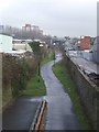
Bristol & Bath Railway Path
The line of the path continues as a railway siding with travelling crane.
Image: © John M
Taken: 1 Feb 2011
0.04 miles
3
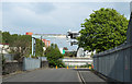
2011 : Princess Street, Bristol
The closed Bristol, Midland Road to Bath railway line ran parallel to the left. Gantries span the gap between a recycling depot and the railway. Image]
Image: © Maurice Pullin
Taken: 17 Apr 2011
0.05 miles
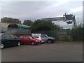
4
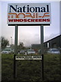
Commercial signage
And matching road name
Image: © Chris Taplin
Taken: 26 Feb 2007
0.07 miles
5
2011 : Closed railway line, Bristol to Bath
Originally the Midland Railway's line between Midland Road Station, Bristol and Green Park Station, Bath via Mangotsfield.
The line is now closed and dismantled and converted to a cycleway. This section appears to be still in use taking waste from a nearby recycling depot.
Image: © Maurice Pullin
Taken: 17 Apr 2011
0.07 miles
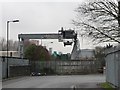
6
Waste transfer station, Princess Street
The crane transfers waste from the council waste facility directly into the waiting freight train.
Image: © David Martin
Taken: 21 Sep 2012
0.08 miles
7
Travelling crane at the waste management depot
Seen from the junction of Princess Street and Folly Lane, on the Bristol and Bath Railway Path 'diversion'.
Image: © Christine Johnstone
Taken: 23 Mar 2013
0.08 miles
8
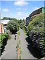
The path from Kingsland Road Bridge
The old railway line that linked St Philips with the Avon Paper Mills has been dug up in the post-Beeching era, resulting in the Dings railway path.
Image: © Neil Owen
Taken: 7 Jul 2022
0.08 miles
9
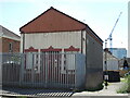
Kingsland Road substation
An electricity building, dating from the mid twentieth century.
Image: © Neil Owen
Taken: 7 Jul 2022
0.09 miles
10
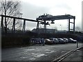
Travelling crane
20 Tonne capacity crane for off loading goods in a railway siding.
Image: © John M
Taken: 1 Feb 2011
0.09 miles