IMAGES TAKEN NEAR TO
Gas Lane, BRISTOL, BS2 0QL
Introduction
This page details the photographs taken nearby to Gas Lane, BS2 0QL by members of the Geograph project.
The Geograph project started in 2005 with the aim of publishing, organising and preserving representative images for every square kilometre of Great Britain, Ireland and the Isle of Man.

There are currently over 7.5m images from over14,400 individuals and you can help contribute to the project by visiting https://www.geograph.org.uk
Image Map (Loading...)


Getting Data...Please wait
Leaflet Map data © OpenStreetMap
Images are licensed for reuse under creativecommons.org/licenses/by-sa/2.0
Notes
- Clicking on the map will re-center to the selected point.
- The higher the marker number, the further away the image location is from the centre of the postcode.
Image Listing (365 Images Found)
Images are licensed for reuse under creativecommons.org/licenses/by-sa/2.0
Image
Details
Distance
1
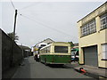
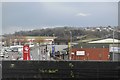
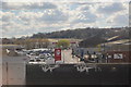
Gas Lane, Looking West
Gas Lane, with vintage Bristol buses making a visit. The works giving the lane its name was behind the wall on the left.
Image: © David Roberts
Taken: 15 Aug 2010
0.01 miles
2
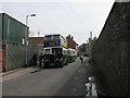
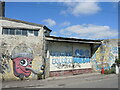
Gas Lane, Looking East
Vintage Bristol buses parked in Gas Lane, viewed looking towards Silverthorne Lane. St Philip's Evangelical Fellowship meets in one of the buildings on the left.
Image: © David Roberts
Taken: 15 Aug 2010
0.02 miles
3
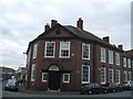
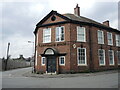
Kingsland House
This late 19th century building is altogether different in style to the grandiose St Vincent's Works on the opposite corner. http://www.geograph.org.uk/photo/1232165
Image: © John M
Taken: 9 Mar 2010
0.03 miles
4
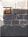
Benchmark on the corner
This mark (as listed in the Benchmark Database: http://www.bench-marks.org.uk/bm41326 ) is on the wall of an office at the junction of Gas Lane, Kingsland Road and Silverthorne Lane. See Image] for a contextual view.
Image: © Neil Owen
Taken: 27 Jan 2012
0.03 miles
6
Car wash in Gas Lane
A colourful entrance in what is a pretty narrow and restrictive road.
Image: © Neil Owen
Taken: 7 Jul 2022
0.03 miles
7
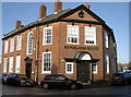
Kingsland House
Situated at the crossroads, this particular building has a cut benchmark on the facing wall. See Image
Image: © Neil Owen
Taken: 27 Jan 2012
0.03 miles
8
A clearer view now
Kingsland House now has a brighter view. The old gasometers in the yard opposite are now cleared. The latter were here since the late nineteenth century, far earlier than the offices.
Image: © Neil Owen
Taken: 29 Apr 2022
0.03 miles
10
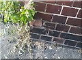
Ordnance Survey Cut Mark
This OS cut mark can be found at the junction of Gas Lane & Kingsland Road. It marks a point 8.473m above mean sea level.
Image: © Adrian Dust
Taken: 24 Sep 2021
0.04 miles