IMAGES TAKEN NEAR TO
Lawfords Gate, BRISTOL, BS2 0NJ
Introduction
This page details the photographs taken nearby to Lawfords Gate, BS2 0NJ by members of the Geograph project.
The Geograph project started in 2005 with the aim of publishing, organising and preserving representative images for every square kilometre of Great Britain, Ireland and the Isle of Man.

There are currently over 7.5m images from over14,400 individuals and you can help contribute to the project by visiting https://www.geograph.org.uk
Image Map
Images are licensed for reuse under creativecommons.org/licenses/by-sa/2.0
Notes
- Clicking on the map will re-center to the selected point.
- The higher the marker number, the further away the image location is from the centre of the postcode.
Image Listing (137 Images Found)
Images are licensed for reuse under creativecommons.org/licenses/by-sa/2.0
Image
Details
Distance
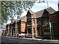
1
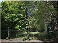
Trinity Road park
A small patch of green is largely surrounded by the busy roads of east Bristol, and contains little more than a circular path and trees. It is an area that has not been touched by the city planners, having remained unblemished by the spade. However, just next door used to be the old (and notorious) Lawford's Gate prison, established in the early 1800s but demolished around the end of the century, becoming a police station.
Image: © Neil Owen
Taken: 5 May 2022
0.02 miles
2
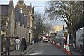
Bristol : Lawfords Gate
Heading up through the streets of Bristol, with traffic cones on the right-hand side.
Image: © Lewis Clarke
Taken: 1 Feb 2013
0.03 miles
3
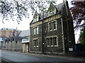
The Assisi Centre
The building was built after the church beside it around the mid-nineteenth century.
Image: © Neil Owen
Taken: 5 May 2022
0.03 miles
4
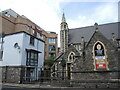
St Nicholas of Tolentino church
The church was founded in the earlier part of the 1800s, and has been extended on occasions since. Beside it used to be a school in the past, which is now replaced by some modern housing that crowds the old church rather.
Image: © Neil Owen
Taken: 5 May 2022
0.04 miles
5
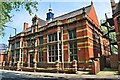
Trinity Road library and vicarage
A fine building designed by William Venn Gough, the library was opened in 1896 but has closed in 2012. Next door is the vicarage to Holy Trinity church (which is also no longer serving as a religious building). Both are now residential and stand on the site of an old saw mill.
Image: © Neil Owen
Taken: 5 May 2022
0.04 miles
6
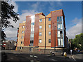
Saint Court, Lawfords Gate
A modern apartment block, presumably named with reference to St Nicholas church beyond it Image
Image: © Stephen Craven
Taken: 24 Jun 2017
0.04 miles
7
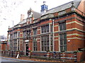
Trinity Road Library
Originally named as St Philips Library (as above the entrance), this public library was designed by William Venn Gough in the Jacobethan style in 1896. It is still a place for the public to come and be enlightened, and is listed as Grade II by English Heritage.
See Image] for a better view of the frontage.
Image: © Neil Owen
Taken: 23 Nov 2011
0.04 miles
8
Trinity Road library
Entrance to the library. See Image] for the longer view.
Image: © Neil Owen
Taken: 23 Nov 2011
0.04 miles
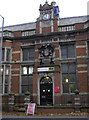
9
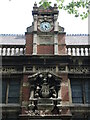
Trinity Road library frontage
The public library was designed by William Venn Gough, who also was responsible for Cabot Tower, Queen Square House, South Street School among other local buildings. It in inscribed as St Philip's Public Library below the clock; below is the city coat of arms. Although it is no longer a library it is still Grade II listed.
Image: © Neil Owen
Taken: 5 May 2022
0.05 miles
10
The former St Philip's Public Library, 1896
Now just The Old Library, this fine late Victorian library by W.V. Gough was built at a time when civic pride and resources were more in evidence than they are in the 21st century.
Image: © Philip Pankhurst
Taken: 12 May 2016
0.05 miles